Drone: Trail Of Damage In Massive Tornado’s Wake
We’re monitoring a dangerous line of storms spanning from the Gulf Coast up through the Ohio Valley today.
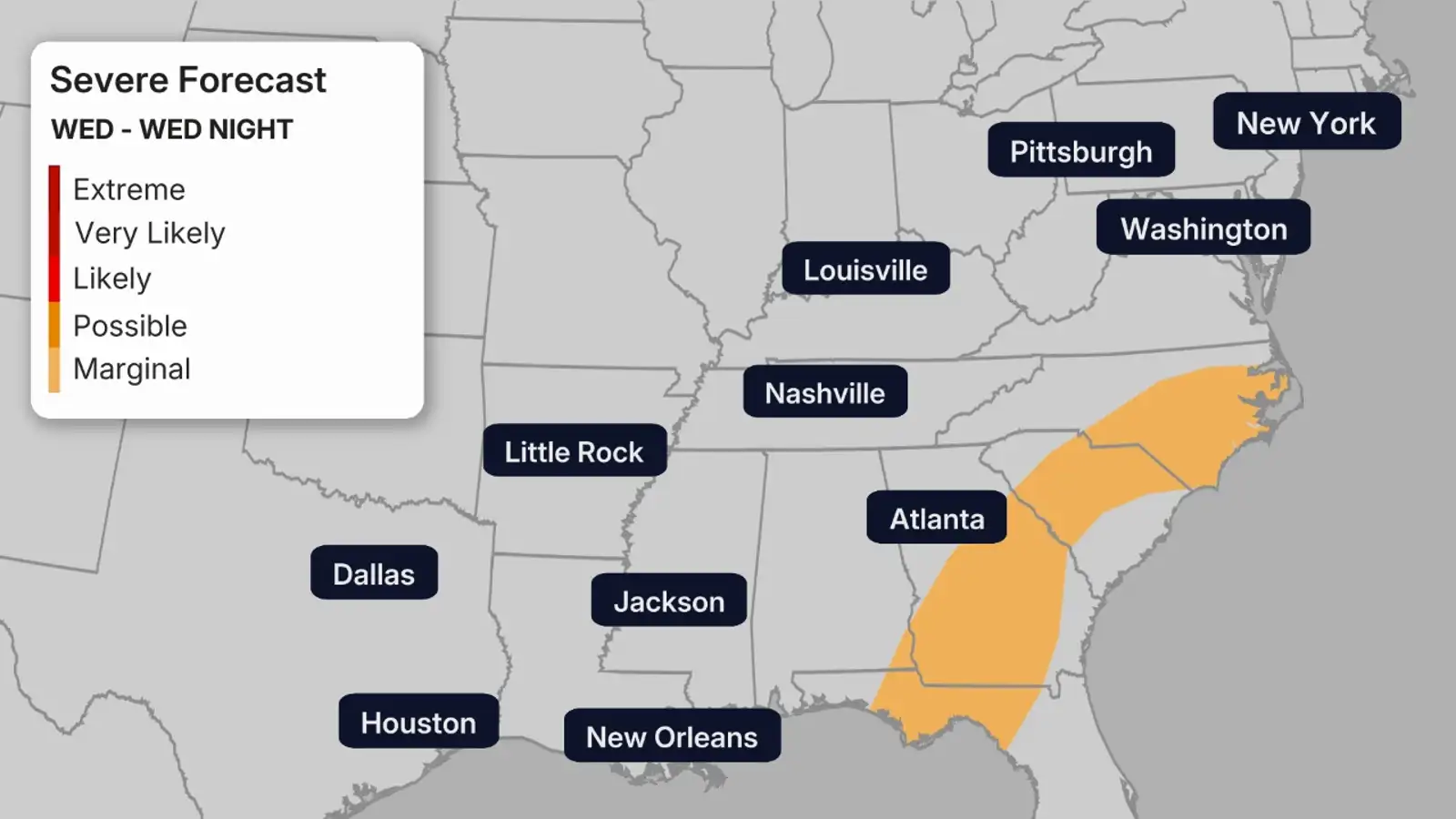
A dangerous line of storms stretched from the Gulf Coast to the Ohio Valley Wednesday, bringing a severe weather threat that had already turned deadly in the Midwest.
As the storms pushed east, we saw scattered reports of tornadoes along with potential for flooding, damaging winds and hail in states like Louisiana, Ohio, Pennsylvania and Maryland.
Weather in your inbox
You can read the full forecast here and track the threat here.
Below is a look at how the severe weather unfolded throughout the evening Wednesday:
(07:48 p.m. EDT) What We’re Watching Overnight
From digital meteorologist Sara Tonks:
While the severe weather threat overall diminishes overnight, there is still the potential for dangerous conditions from the Gulf Coast to the mid-Atlantic from isolated to scattered severe thunderstorms.
In the Appalachian mountains and mid-Atlantic, a tornado and wind threat will hold on into the early morning hours. Further south, the severe weather threat has not yet peaked, including cities like New Orleans and Mobile, Alabama.
Everyone in the path of these storms should take time to make sure they are prepared for severe storms before going to bed, just in case. This includes making sure you have a reliable way (and a backup way) of getting severe weather alerts, charging your devices and sleeping in an interior or lower-level room of your home, if possible.
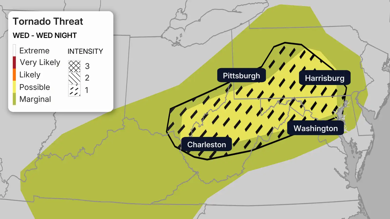
(07:35 p.m. EDT) Regional Breakdown: Central Appalachian Mountains, Mid-Atlantic
From digital meteorologist Sara Tonks:
The northern area that is at a higher risk of tornadoes will see the threat end closer to midnight. The southern area could see tornadoes and severe storms overnight. The threat steadily drops off after midnight for cities like Pittsburgh, Philadelphia and Washington DC, though strong winds will remain possible into the early morning hours of Thursday.
The threat of large hail is actually highest in this region for today’s severe weather, but it is still not as high as the threat yesterday.
There is also a slight threat (level 2 out of 4) of excessive rainfall and flash flooding in part of the Allegheny Plateau in southern Ohio, northern West Virginia and southwestern Pennsylvania. Rainfall rates could reach 1 to 1.5 inches per hour, and additional localized rainfall totals up to 2 to 3 inches are possible.
(07:22 p.m. EDT) Eyes On Warned Tornadoes
Two areas are grabbing our attention right now as storms continue to move east.
In central Louisiana, a spotted tornado has been reported near the community of Effie, where storms are intensifying and prompting urgent warnings for people in the area.
Meanwhile, farther north, a radar-indicated tornado and a hail threat are moving toward the Baltimore metro area. Forecasters say storms there are showing signs of rotation.
(06:53 p.m. EDT) What You Should Know About Hail
As we’re tracking potential for hail in places like Cincinnati, Baltimore and even Pittsburgh, it’s important to explain just how much hail can vary in size, and how that size determines the damage it’s capable of doing.
Most hail you see is pea-sized, which is the smallest on the common hail scale. Golf ball–sized hail (around 1.75 inches) can start denting cars, while baseball-sized hail (about 2.75 inches) is strong enough to smash windshields.
Softball-sized hail can even punch holes in roofs and be dangerous to human life.
For more on why the hail scale exists and what you should know, click here.
(06:32 p.m. EDT) Flash Flood Warning Issued In Southern Ohio
A flash flood warning has been issued in southern Ohio, including Chillicothe, after radar indicated between 1.5 and 2 inches of rain had already fallen, with over an inch more possible. There are currently no monitoring stations reporting rivers in flood stage, though Paint Creek near Bourneville is in action stage, according to the National Water Prediction Service.
(06:12 p.m. EDT) Latest Watches And Warnings
As storms are rolling across parts of the South and mid-Atlantic, a few new watches and warnings have been added since our last check:
- In the South, a Severe Thunderstorm Watch is now in effect for northern Alabama and Middle Tennessee, including Huntsville, until 8 p.m. local time.
- Farther east, a Severe Thunderstorm Warning is active in northwestern Virginia.
- In south-central Pennsylvania, a Tornado Warning is in effect for Cumberland, Dauphin and Perry counties, with radar showing rotation near Rockville and moving toward Duncannon and Marysville.
Remember, a Tornado Watch is already covering parts of the Maryland panhandle, southern Pennsylvania and northern Virginia through 8 p.m. EDT, so these storms are worth keeping a close eye on.
(05:55 p.m. EDT) Regional Breakdown: Tennessee Valley/Lower Ohio Valley
This is the region at the lowest risk for tornadoes, so the main threat will be strong winds overnight, though isolated tornadoes, large hail and flash flooding are all possible as well. The overall severe threat starts to drop off around sunset, but damaging winds remain possible until roughly midnight.
(05:37 p.m. EDT) Watching Power Outages
We’re keeping a close eye on power outages as these storms sweep across the country, bringing hail, damaging winds and the potential for downed trees and power lines.
Right now, Ohio appears to be taking the biggest hit, with around 12,000 outages reported on PowerOutage.us.
And here’s something our meteorologists are watching closely tonight: when storms push into the Northeast, reports of trees down often spike dramatically. If that pattern holds, outages could climb quickly as the evening goes on.
(05:13 p.m. EDT) Regional Breakdown: Deep South/Gulf Coast
This is one of the regions at a higher risk of tornadoes tonight, though the threat is not as high as it was in other parts of the country yesterday. The potential for tornadoes is highest from Louisiana across southern Mississippi and Alabama into the Florida Panhandle. Damaging winds will quickly become the main threat for cities like New Orleans and Mobile, Alabama, overnight as the storms move eastward, though tornadoes are still possible.
Flash flooding is also possible in the region, as rainfall rates could reach up to 2 inches per hour and some localized totals of 3 to 5 inches of rain.
Many areas could see their highest threat of severe weather during hours when most people are asleep, so having an overnight severe weather plan in place before you go to bed is important.
(04:52 p.m. EDT) Don’t Ignore The Threat Of Damaging Winds
From digital meteorologist Sara Tonks:
While tornadoes are one of the big threats we’re watching today, it’s important not to ignore the threat of severe weather in the form of straight-line winds. Strong winds will likely become the main threat as the night progresses.
The threat of damaging winds peaks today along the northeastern Gulf Coast (from southeastern Louisiana through southern Mississippi and Alabama into the Florida Panhandle) and in the central Appalachian mountains (including southern Ohio, much of West Virginia, southwestern Pennsylvania and the Maryland panhandle).
Strong winds associated with thunderstorms are, by far, the most common form of severe weather in the United States, even if they don’t get the same level of attention from the public.
(04:33 p.m. EDT) The Latest From The Storm Prediction Center
Here’s the latest thinking from forecasters at the Storm Prediction Center, including a few subtle shifts from what we’ve been keeping our eyes on.
Storms in Tennessee are expected to mainly bring gusty winds and possibly some small hail over the next few hours, rather than a bigger tornado threat.
Meanwhile, storms in southeast Texas are forecast to move east overnight, and that’s where forecasters say the risk could actually tick up a bit, with stronger winds and a chance for a few tornadoes.
Farther north, storms across the Ohio Valley into the Appalachians haven’t been quite as widespread as earlier forecasts suggested. Even so, scattered storms are still ongoing, and there’s still a lingering risk for severe weather, especially in parts of Pennsylvania.
(04:13 p.m. EDT) What Made Last Night So Impactful?
The system we’re watching was especially rough across Northern Illinois and Indiana overnight. Meteorologist Rob Shackelford breaks down exactly why here.
(03:42 p.m. EDT) A Look At Yesterday’s Devastation In Indiana
The full scope of the damage is still coming into focus in Lake Village, Indiana, where a tornado from the same powerful storm system we’re watching today flattened homes and left debris scattered as far as the eye can see.
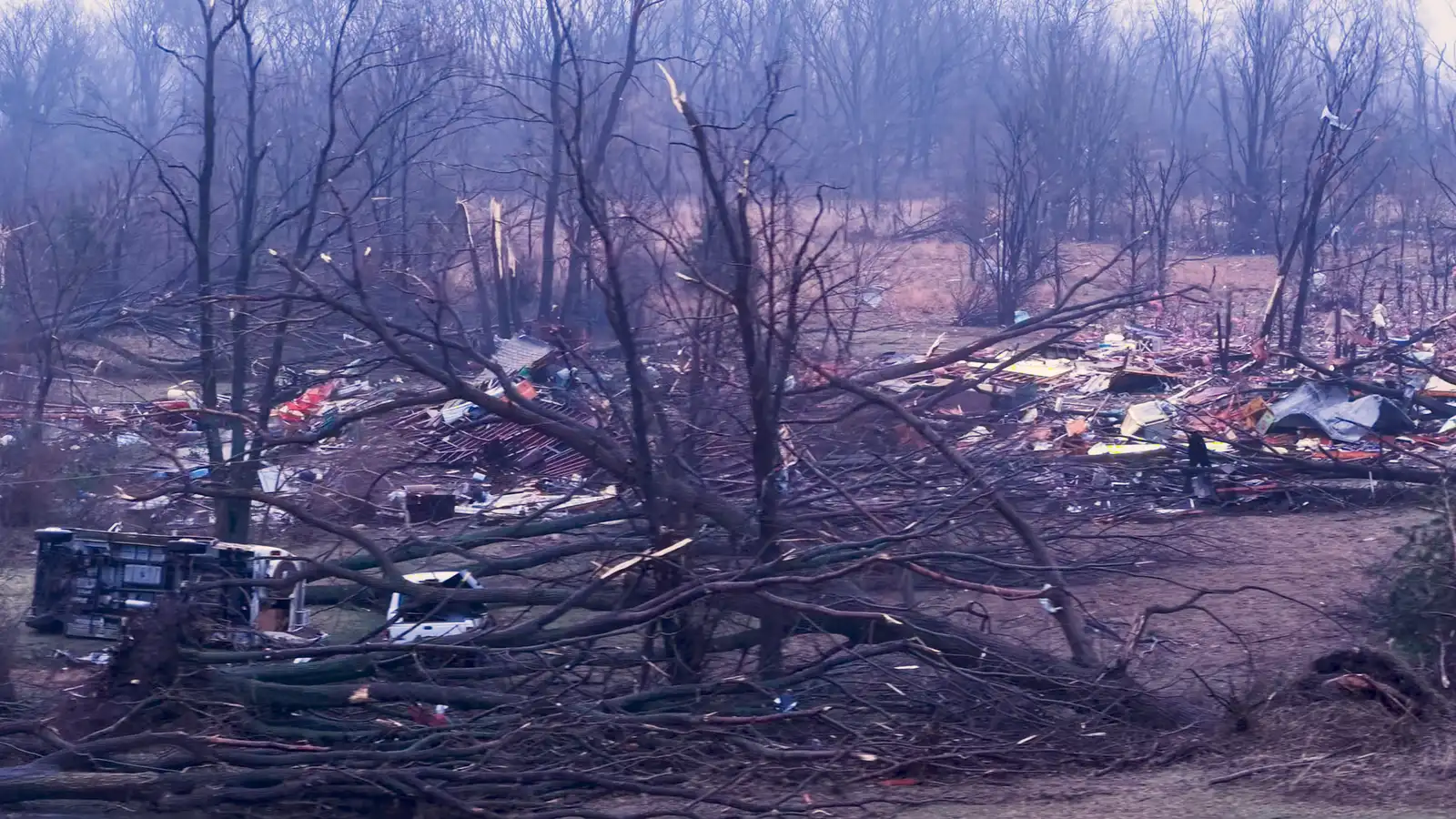
The storm tore through the area late last night, killing at least two people. Rescue crews have been on scene working to find survivors.
Watch the devastating footage here.
(03:09 p.m. EDT) What We’re Watching Now
Several tornado watches remain in effect as this system pushes east:
Right now, tornado watches through this afternoon stretch from southern Indiana through northeastern Kentucky and southeastern Ohio through northern West Virginia, including cities like Louisville and Cincinnati.
Another tornado watch is in effect farther south for parts of southeast Texas and western Louisiana, including Houston and Lake Charles, until early this evening.
Farther east, a new tornado watch now covers parts of the Maryland panhandle, northern Virginia, southwestern Pennsylvania and northeastern West Virginia through 8 p.m. local time as the storm threat spreads toward the Appalachians.
(02:50 p.m. EDT) Potential Record-Breaking Hailstone
From digital meteorologist Sara Tonks:
Severe weather yesterday brought not just damaging winds and tornadoes but also massive hail reported up to 6 inches (half a foot) in diameter. To put that into perspective, that’s larger than a grapefruit by 1.5 inches (which is often the upper limit of hail size charts).
The National Weather Service office in Chicago is investigating a reported six-inch hailstone from Kankakee, Illinois, which would smash the record for the largest reported hailstone in the state of Illinois by 1.25 inches. The current official record is from a hailstone that measured 4.75 inches in Minooka, Illinois, in June of 2015.
There were, in fact, six reports of hail larger than 4.75 inches from yesterday’s storms, but the NWS office will focus on the largest reported stone for the new record.
(02:29 p.m. EDT) If You’re Playing Catch-up
This storm system has already unleashed chaos across parts of the Plains and Midwest, where more than 10 million people were under a tornado threat yesterday. Power outages, airport disruptions and destructive storms hit states including Texas, Oklahoma, Illinois and Indiana after the Storm Prediction Center issued a rare Level 4 out of 5 severe weather risk — its highest outlook so far this year.
By early this morning, the National Weather Service had received about 230 severe weather reports. Most notably, one long-lived supercell tracked more than 120 miles from northeast Illinois into northern Indiana over a span of more than four hours, spawning tornadoes in Kankakee, Illinois, and Lake Village and Wheatfield, Indiana. Survey teams have already confirmed the tornado that struck Wheatfield was an EF1 in strength.
(02:15 p.m. EDT) Today’s Forecast
From senior digital meteorologist Jonathan Belles:
Severe thunderstorms are possible this afternoon and evening from the central Appalachians through the Tennessee Valley and into the northern Gulf Coast. The overall threat in this area will be lower than Tuesday’s threat — a step down from yesterday’s level 4 to a level 2.
There are two areas we’re watching for tornadoes: One along the northern Gulf Coast and another in the northern Appalachians. The biggest cities in these areas are Houston, New Orleans and Pittsburgh. Damaging winds and large hail are also possible today.
Storms are already flaring across this area and will continue through late evening in the northern stretch of this area and possibly through the night across the South.