A potent winter storm is set to hit Colorado on Tuesday, bringing blinding snow squalls in the mountains and fire danger.
DENVER — A potent winter storm will impact Colorado Tuesday, with snow squalls and periods of heavy snow in the mountains, near-record heat and high fire danger to the foothills and the plains.
Weather Impact Alert Tuesday
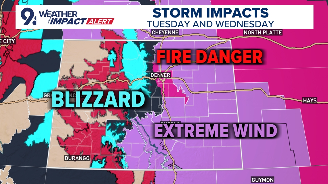
The 9NEWS Weather Impact Team issued a Weather Impact Alert on Tuesday as an atmospheric river storm system sets up in Colorado.
Blinding snow squalls in the mountains, extreme winds between 60 and 85 mph, and elevated grass fire danger are the major concerns with mountain impacts continuing into Wednesday.
9NEWS Weather Impact Team meteorologist Chris Bianchi said Colorado’s biggest mountain snow event of the season will last from Tuesday night to Saturday morning, with three waves of snow. Isolated mountain impacts continuing into Wednesday before yet another wave of snow on Thursday.
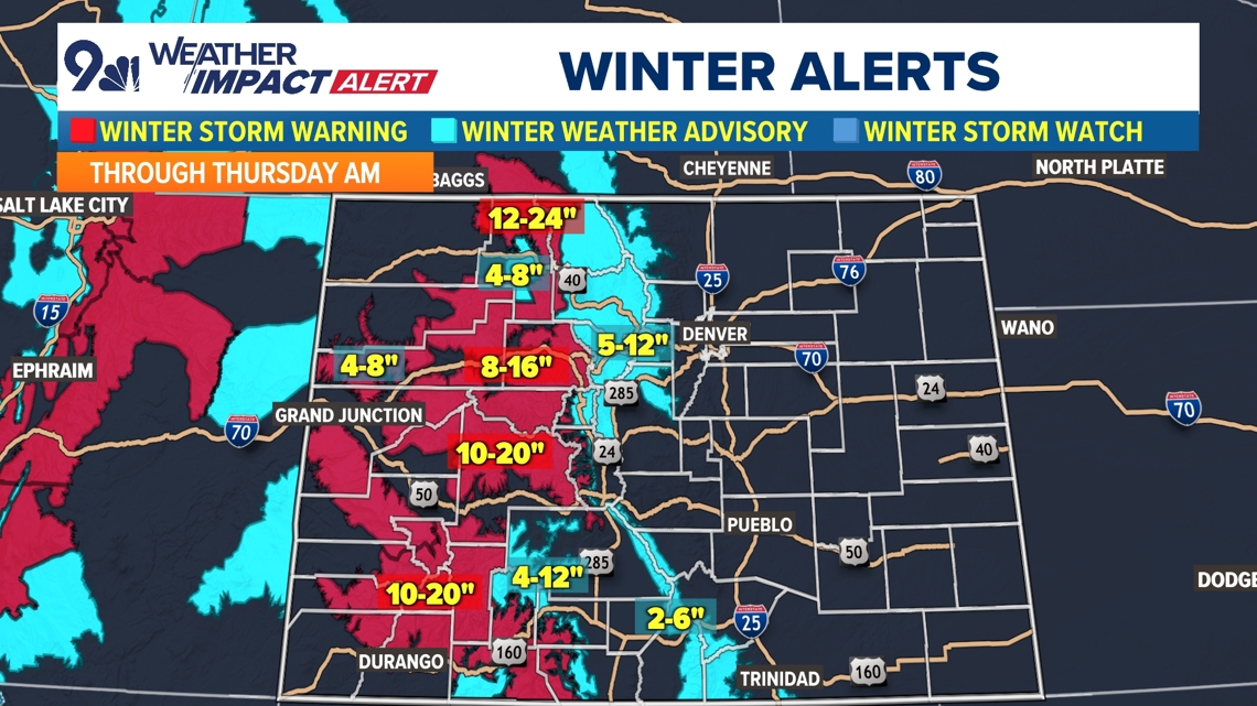
A Winter Storm Warning for Archuleta, Delta, Dolores, Eagle, Garfield, Gunnison, Hinsdale, La Plata, Moffat, Montezuma, Ouray, Pitkin, Rio Blanco, Routt, San Juan & San Miguel counties is in effect until 5 a.m. Thursday morning.
The 9NEWS Weather Impact Team is calling for 3-20 inches of snow across Colorado’s mountains from Tuesday morning to Wednesday night. There could be isolated pockets of up to a foot of snow on the high mountain passes and peaks.
Snow squalls will make mountain travel very difficult, if not impossible on Tuesday morning in particular. Mountain travel will be tough between 4 and 10 a.m. in particular due to a combination of snow and wind.
Wind gusts of up to 70 mph will accompany those snow showers at times creating snow squalls and zero visibility blizzard conditions. Driving in the mountains will be difficult Tuesday morning and night and also on Wednesday morning.
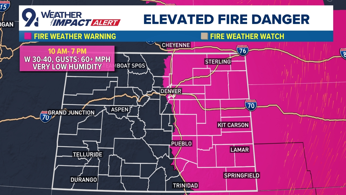
Fire danger on Front Range
The Denver metro area and Front Range will likely have the lowest impacts from this storm, but 30-50 mph wind gusts could be frequent on Tuesday elevating the grass fire danger in the area.
The stronger winds will be in areas surround the Front Range with up to 60 mph winds possible in the foothills, the base of the foothills, the Palmer Divide and the northeast plains. And the extreme winds will be to the south where spots in the Sangre de Cristo Range could see wind gusts close to 85 mph which could spill out onto the southeast plains.
Hundreds of flights at Denver International Airport were delayed Tuesday.
RELATED: Hundreds of flights delayed at Denver airport as strong winds impact Colorado’s Front Range


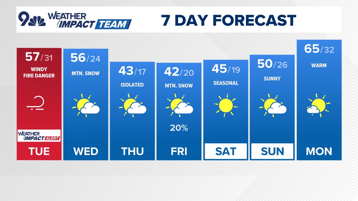
Denver Forecast
- TUESDAY: Mild and windy with a chance for isolated showers. High 57, low 31.
- WEDNESDAY: Partly sunny and cooler. High 55, low 24.
- THURSDAY: Partly cloudy with a chance for light rain/snow. High 43, low 17.
- FRIDAY: Partly cloudy and seasonally chilly. High 42, low 20.
- SATURDAY: Clearing and cool. High 45, low 19.
- SUNDAY: Mostly sunny, breezy and warmer, High 52, low 26.