
Increasing clouds and humidity levels tonight as we gear up for a rare high intense summertime severe weather around western Pennsylvania. Tomorrow is a Severe Weather Alert Day.Severe Weather Alert Day TuesdayTuesday is a Severe Weather Alert Day with the threat for severe weather. A high energy system with strong wind shear arrives from the Great Lakes. We could deal with two waves of thunderstorms – the first around mid-day and a second during the early evening. The intensity and coverage of the first round will determine what’s to come late-day.Our entire region is already outlooked in a level three out of five risk for severe thunderstorms. Damaging winds are a high storm risk, followed by a few tornadoes and large hail. Rain will come down hard with a greater threat for flash flooding near and south of I-70.The window for storms will open as early as 10 a.m. The second round could hit starting at 6 p.m. All activity will subside as the sunsets.Cool for late JulyWe turn more pleasant behind Tuesday’s strong system. Humidity levels will drop with highs in the mid 70s Wednesday and Thursday. It will feel more like September.Quiet trend through the weekendOccasional bouts of wildfire smoke could hover over us, but it will be nothing like we dealt with last week. The pattern remains fairly quiet through next weekend. Our next rain chance holds off until next Monday, at the earliest. TONIGHT: Becoming mostly cloudy. Low 66°.TUESDAY – Severe Weather Alert Day: Rain and thunderstorms, likely strong to severe. High: 84°, low: 67°.WEDNESDAY: Breezy, cooler and less humid with partly cloudy skies. High: 76°, low: 55°.THURSDAY: Refreshing start, pleasant finish with more sunshine. High: 78°, low: 58°.
Increasing clouds and humidity levels tonight as we gear up for a rare high intense summertime severe weather around western Pennsylvania. Tomorrow is a Severe Weather Alert Day.
Severe Weather Alert Day Tuesday
Tuesday is a Severe Weather Alert Day with the threat for severe weather. A high energy system with strong wind shear arrives from the Great Lakes. We could deal with two waves of thunderstorms – the first around mid-day and a second during the early evening. The intensity and coverage of the first round will determine what’s to come late-day.
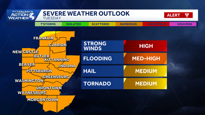
Our entire region is already outlooked in a level three out of five risk for severe thunderstorms. Damaging winds are a high storm risk, followed by a few tornadoes and large hail. Rain will come down hard with a greater threat for flash flooding near and south of I-70.
The window for storms will open as early as 10 a.m. The second round could hit starting at 6 p.m. All activity will subside as the sunsets.
Cool for late July
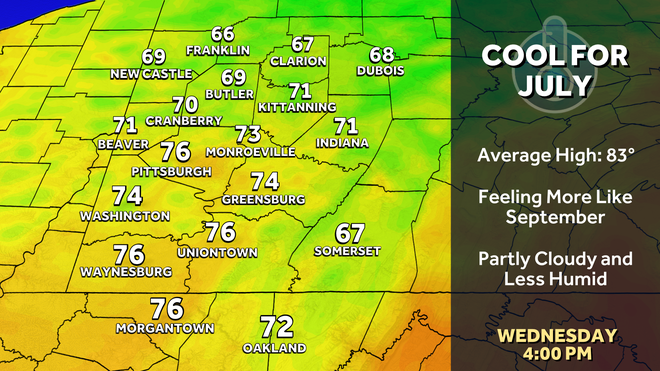
We turn more pleasant behind Tuesday’s strong system. Humidity levels will drop with highs in the mid 70s Wednesday and Thursday. It will feel more like September.
Quiet trend through the weekend
Occasional bouts of wildfire smoke could hover over us, but it will be nothing like we dealt with last week. The pattern remains fairly quiet through next weekend. Our next rain chance holds off until next Monday, at the earliest.
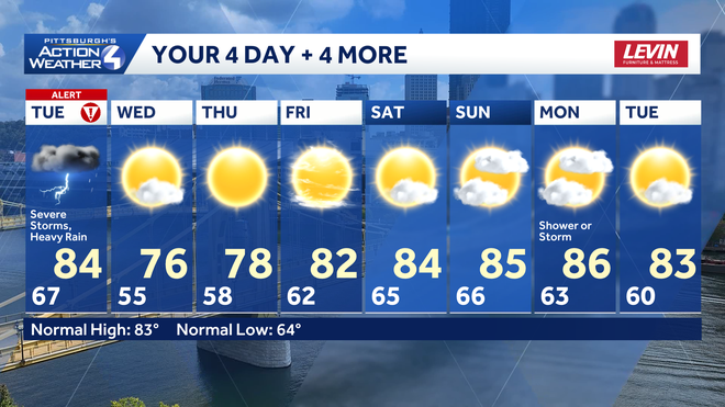
TONIGHT: Becoming mostly cloudy. Low 66°.
TUESDAY – Severe Weather Alert Day: Rain and thunderstorms, likely strong to severe. High: 84°, low: 67°.
WEDNESDAY: Breezy, cooler and less humid with partly cloudy skies. High: 76°, low: 55°.
THURSDAY: Refreshing start, pleasant finish with more sunshine. High: 78°, low: 58°.