
Severe storms, flooding downpours to focus on Plains, Midwest, Great Lakes into Easter weekend
Heavy to severe thunderstorms and potentially flooding rain will affect parts of the Plains, Mississippi Valley and Great Lakes into Easter weekend. Travel and outdoor plans may be disrupted, with locally dangerous conditions expected, especially where storms occur after dark.
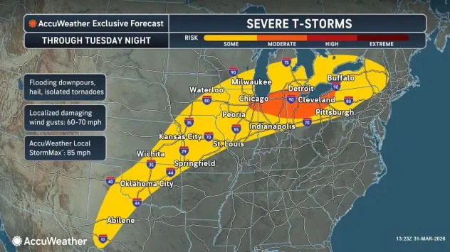
Severe storm risk on Tuesday to extend 1,400 miles
On Tuesday, the risk of severe weather will broaden from southern Wisconsin and northern Illinois, extending east through much of upstate New York and northern and western Pennsylvania and southwestern to central Oklahoma and parts of central Texas.
AccuWeather.com
“Tuesday’s storms may bring large hail, damaging wind gusts and a few tornadoes, with the greatest concentration from southern Michigan to northeast Illinois, the northern parts of Indiana and Ohio and northwest Pennsylvania,” AccuWeather Meteorologist Brandon Buckingham said.
The AccuWeather Local StormMax™ wind gust for Tuesday is 85 mph.
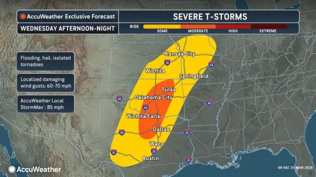
Wednesday’s severe storms to focus over South Central states
On Wednesday, the severe weather threat is forecast to shift south and consolidate over the Plains and parts of the Mississippi Valley. Severe weather is anticipated from central Texas through central and southeastern Kansas into southwestern and central Missouri.
AccuWeather.com
As on Tuesday, a more concentrated zone of severe storms with large hail, damaging wind gusts and a few tornadoes is forecast. That zone is likely to extend from north-central Texas, including Dallas, into central and northeastern Oklahoma, including Tulsa and Oklahoma City.
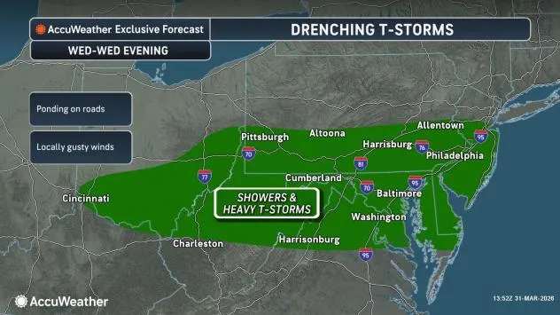
Few big storms, big downpours in mid-Atlantic on Wednesday
Farther to the east, heavy thunderstorms will drench portions of the Ohio Valley and the mid-Atlantic region Wednesday. Along with downpours that can slow travel, some storms may produce winds strong enough to break tree branches and send trash cans and recycling bins flying.
AccuWeather.com
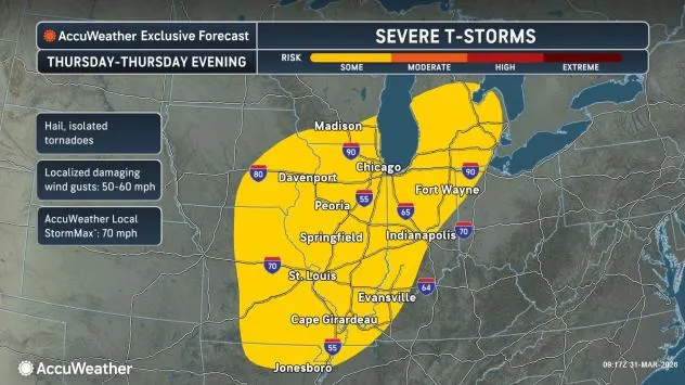
Thursday’s severe weather risk returns to Midwest
The risk of severe weather will continue across parts of the Mississippi Valley and Plains Thursday and Friday, with Thursday’s storms capable of producing strong wind gusts and hail from northern Arkansas to southern Michigan.
AccuWeather.com
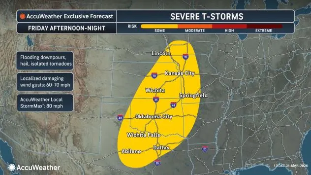
Friday night’s severe weather risk returns to southern, central Plains
From late Friday to Friday night, the severe weather threat will shift farther southwest as another storm moves out of the Rockies. By Friday night, the severe weather threat zone will extend from central Texas to southwestern Iowa.
AccuWeather.com
The strongest storms on Friday may produce high wind gusts, hail and a few tornadoes.
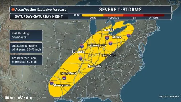
On Saturday, the risk of severe thunderstorms will extend along an advancing cold front from northeast Texas to southwest Ontario and western New York. The main threats will be from damaging hail and wind gusts.
AccuWeather.com
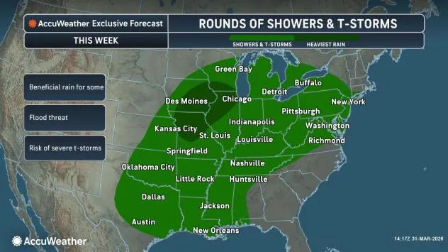
Rain to be beneficial for some, problematic for others
As the parent storm lifts northeast across the Great Lakes this weekend, a trailing cold front will trigger drenching showers and locally severe thunderstorms as it pushes eastward and southward across the Mississippi Valley and the Appalachians.
GET THE FREE ACCUWEATHER APP
•Have the app? Unlock AccuWeather Alerts™ with Premium+
Each round of showers and thunderstorms may bring localized flash and urban flooding. Where downpours repeat daily or every other day, the risk of small-stream flooding and significant rises on some rivers will persist.
AccuWeather.com
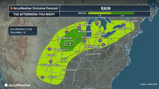
A general 1-4 inches of rain is forecast this week from Texas and the north-central Gulf Coast to the Great Lakes and central Appalachians, with locally higher amounts of up to 6 inches possible. While not all of the rain will fall at once, multiple rounds of disruptive rainfall are likely.
AccuWeather.com
In drought-stricken areas, repeated rainfall may bring some relief and reduce the risk of spring wildfires.
While much of the central and southern Plains and Mississippi Valley face downpours and severe weather, winter will stage a comeback across the northern tier of the central and northeastern U.S., bringing widespread snow and ice.
Want next-level safety, ad-free? Unlock advanced, hyperlocal severe weather alerts when you subscribe to Premium+ on the AccuWeather app. AccuWeather Alerts™ are prompted by our expert meteorologists who monitor and analyze dangerous weather risks 24/7 to keep you and your family safer.