Let’s take a look at the latest information about the upcoming snow storm this weekend.
COPYRIGHT 2026 BY CHANNEL 3000. ALL RIGHTS RESERVED. THIS MATERIAL MAY NOT BE PUBLISHED, BROADCAST, REWRITTEN OR REDISTRIBUTED.
Download the First Warn Weather app here
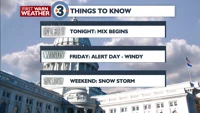
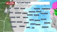
WHAT WE’RE TRACKING:
Rain/snow mix moves into Wisconsin later Thursday afternoon, lasts through Friday afternoon
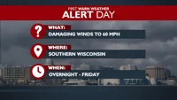
ALERT DAY Friday for strong wind gusts up to 60 miles per hour
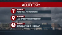
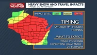
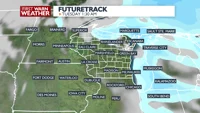
ALERT DAY for a winter storm Saturday night through Monday
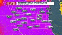
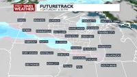
PLANNINGTHE NEXT24HOURS: Our next Clipper is going to bring a rain/snow mix beginning later Thursday afternoon and will move eastward throughout Thursday night and Friday. While the rain/snow mix will be on the light side, winds are going to be breezy; there is a high wind warning for southern Wisconsin from 4am – 4pm Friday. Winds could gust up to 60 miles per hour turning from the southwest to the northwest throughout Friday.
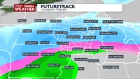
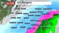
EXTENDEDFORECAST: Then attention turns to the weekend when a large, winter storm will move through the Midwest beginning Saturday night. This system’s path will take it through the Chicagoland/northwestern Indiana area, which still puts southern Wisconsin in the optimal spot to receive a decent amount of snow.
However, the freezing line is going to play an important factor this next system. Those north of the freezing line will likely experience snow throughout the entire weekend while those south of the line will first see rain or a rain/snow mix which will turn over to all snow by later Sunday.
While it is still too early to talk snow totals, most of southern Wisconsin should prepare for, at least, 6″ of wet, heavy snow. There’s a chance that some folks, especially further northeast, could receive between 1-2 feet of snow.
COPYRIGHT 2026 BY CHANNEL 3000. ALL RIGHTS RESERVED. THIS MATERIAL MAY NOT BE PUBLISHED, BROADCAST, REWRITTEN OR REDISTRIBUTED.
Humidity: 62%
Feels Like: 29°
Heat Index: 40°
Wind: 28 mph
Wind Chill: 29°
UV Index: 0 Low
Sunrise:07:14:53 AM
Sunset:07:00:53 PM
Dew Point: 28°
Visibility: 7 mi
Today
Mostly cloudy and windy with scattered rain and snow showers. Some snow accumulation possible, mainly for areas north of The Dells.
Wind: SW 15-25 MPH, gusts to 50 MPH
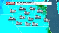
Tonight
Mostly cloudy and windy with scattered rain and snow showers. Some snow accumulation possible, mainly for areas north of The Dells.
Wind: SW 15-25 MPH, gusts to 50 MPH
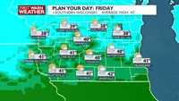
Tomorrow
Becoming partly sunny, windy, and seasonable with a slight chance of rain and snow showers early.
Wind: NW 20-30 MPH, with gusts up to 55 MPH
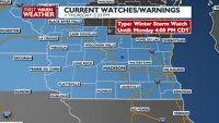
...WINTER STORM WATCH REMAINS IN EFFECT FROM SATURDAY EVENING
THROUGH MONDAY AFTERNOON...

* WHAT...Heavy snow and blowing snow is possible Saturday night and
Sunday,
especially toward central WI. A wintry mix will be possible for a
time Saturday night and Sunday, including a chance for sleet and
freezing rain with some accumulating ice looking increasingly
likely. Ice accumulation is most likely along and north of I-94.
Rain may also mix in for a time mainly south of I-94. The wintry
mix is expected transition to moderate to heavy snow across
southern Wisconsin Sunday evening, persisting into Monday. Strong
winds and blowing snow will likely continue into Monday as well.

* WHERE...Portions of east central, south central, and southeast
Wisconsin.

* WHEN...From Saturday evening through Monday afternoon.

* IMPACTS...Visibilities may drop below 1/4 mile due to falling and
blowing snow. The strong winds and weight of snow on tree limbs
may down power lines and could cause sporadic power outages.
Travel could be very difficult to impossible. Areas of blowing
snow could significantly reduce visibility. The hazardous
conditions could impact the Monday morning commute. Gusty winds
could bring down tree branches.

* ADDITIONAL DETAILS...There remains a fair amount of uncertainty
with the track of this
system as well as resultant precipitation types and amounts.

PRECAUTIONARY/PREPAREDNESS ACTIONS...

Monitor the latest forecasts for updates on this situation.

&&
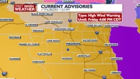
...HIGH WIND WARNING REMAINS IN EFFECT UNTIL 4 PM CDT FRIDAY...

* WHAT...Initially, south winds 20 to 30 mph with gusts up to 60 mph
expected,
particularly within precipitation. Then, west winds 20 to 30 mph
with gusts up to 60 mph expected.

* WHERE...Portions of east central, south central, and southeast
Wisconsin.

* WHEN...Until 4 PM CDT Friday.

* IMPACTS...Damaging winds will blow down trees and power lines.
Widespread power outages are expected. Travel will be difficult,
especially for high profile vehicles.

* ADDITIONAL DETAILS...The primary reason for moving the High Wind
Warning up in time
was to cover the potential for high end winds within the expected
precipitation tonight. It is uncertain but the risk is high enough
that it should be addressed.


PRECAUTIONARY/PREPAREDNESS ACTIONS...

Remain in the lower levels of your home during the windstorm, and
avoid windows. Watch for falling debris and tree limbs. Use caution
if you must drive.

&&
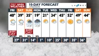
Thu Thursday
44°/33°
Windy with rain at times. Lows overnight in the mid 30s.
Thursday Night
Mostly cloudy and windy with scattered rain and snow showers. Some snow accumulation possible, mainly for areas north of The Dells.
Wind: SW 15-25 MPH, gusts to 50 MPH
Fri Friday
40°/27°
Considerably cloudy, windy. Highs in the low 40s and lows in the upper 20s.
Friday Night
Mostly cloudy and a little cooler. Wind: NW 10-15, with gusts up to 25 MPH.
Sat Saturday
39°/31°
Mostly cloudy. Highs in the low 40s and lows in the low 30s.
Saturday Night
Breezy with scattered rain and snow showers developing at night. Some snow accumulation is possible, mainly areas north of Madison.
Sun Sunday
38°/14°
Watching a potential winter storm. Rain and wind. Highs in the upper 30s and lows in the mid teens.
Sunday Night
Mostly cloudy, windy, and colder with periods of snow at night, especially early. Snow accumulation is likely with blowing and drifting of snow. Wind chills could drop below zero.
Mon Monday
20°/1°
Windy, snow early. Highs in the upper teens and lows in the low single digits.
Monday Night
Partly cloudy and very cold. Wind chills near -5.
Tue Tuesday
21°/10°
Mostly sunny. Highs in the low 20s and lows in the mid teens.
Tuesday Night
Mostly cloudy and cool with a slight chance for snow.
Wed Wednesday
34°/25°
Cloudy. Highs in the low 40s and lows in the upper 20s.
Wednesday Night
Mostly cloudy.
Thu Thursday
45°/30°
Mix of sun and clouds. Highs in the upper 40s and lows in the low 30s.
Thursday Night
Mostly cloudy.
Fri Friday
52°/35°
Times of sun and clouds. Highs in the mid 50s and lows in the low 30s.
Friday Night
Partly cloudy.
Sat Saturday
49°/36°
Partly cloudy. Highs in the low 50s and lows in the upper 20s.