
Midwest Severe Threat Lasts Into Night
Severe thunderstorms will continue to erupt over parts of the Plains, Midwest and Northeast through Saturday, with tornadoes, hail, damaging winds and flooding rain in another multi-day siege that began Monday.
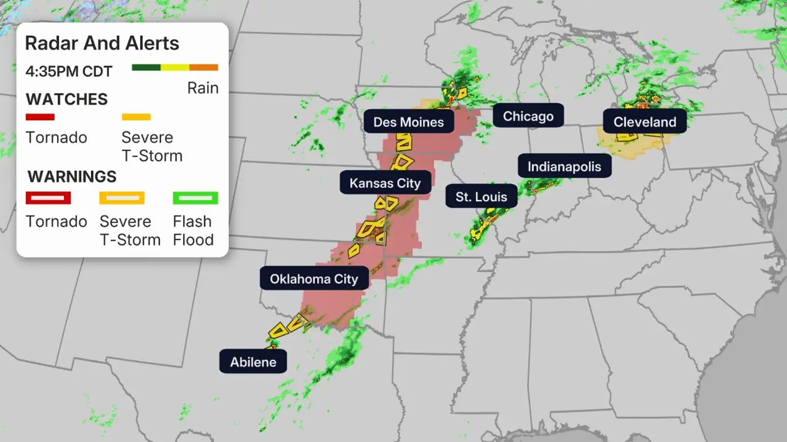
Happening Now
Scattered showers and storms are ongoing across the Plains and the southern Great Lakes.
NOAA’s Storm Prediction Center has issued the following severe weather watches:
– A tornado watch has been issued for parts of northwest Arkansas, southeastern Kansas, southwestern Missouri and eastern and central Oklahoma until 9 p.m. CDT. This includes Oklahoma City and Tulsa, Oklahoma; and Springfield, Missouri.
– A tornado watch has been issued for far northwestern Illinois, southern Iowa, eastern Kansas and northern Missouri until 9 p.m.
– A severe thunderstorm watch valid until 7 p.m. CDT for parts of central Iowa.
– A severe thunderstorm watch has been issued for parts of southeast Michigan, northern Ohio and northwestern Pennsylvania until 9 p.m. EDT, including Cleveland, Ohio.
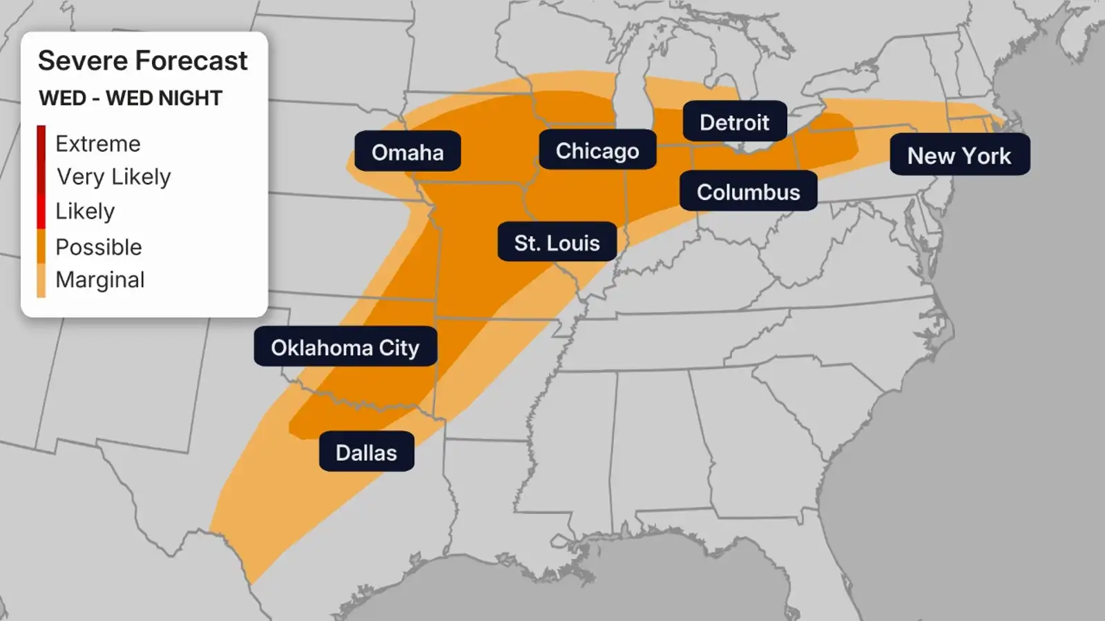
Severe Forecast
Wednesday
Yet more clusters of severe t-storms with hail, damaging winds, a few tornadoes and locally flooding rainfall will sprout again Wednesday from the Southern Plains to the Midwest and interior Northeast, in many of the same areas already hit this week.
Thursday
Thursday’s severe storm threat appears lower and more isolated from parts of the interior Northeast to the mid-Mississippi River Valley. The most focused area for severe weather is in Upstate New York to central New England. A few tornadoes, damaging wind and some hail are possible.
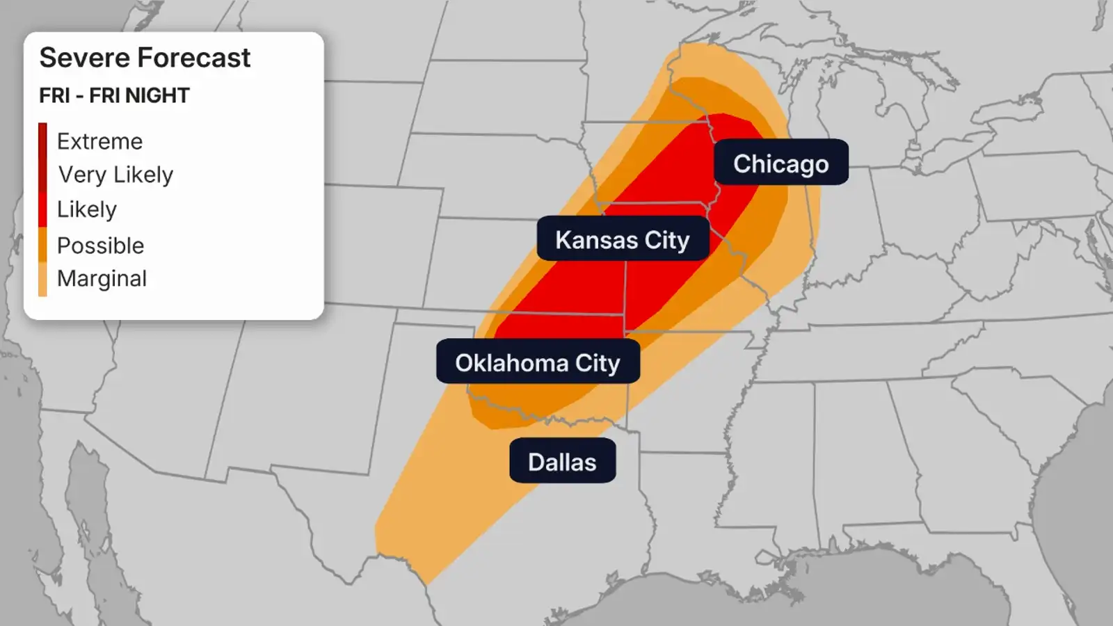
Friday
Unfortunately, a more serious threat of severe thunderstorms is in play Friday afternoon and night.
And once again it’s from the Southern Plains to the Cornbelt.
Both supercell thunderstorms with tornadoes — some of which could be strong — and one or more squall lines of severe thunderstorms with damaging winds and embedded tornadoes are possible, especially in the darker shaded areas in the map below.
Saturday
There may still be at least some isolated to scattered severe thunderstorms ahead of a cold front Saturday from the Great Lakes and Ohio Valley to Texas.
But we’re not expecting this activity to be nearly as widespread as Friday.
Fortunately, the nation should get at least a two-day break from severe weather as the cold front sweeps off the East Coast Sunday.
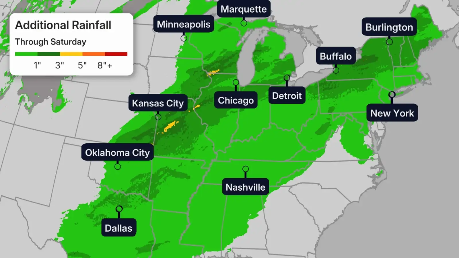
Flood Forecast
The combination of previous rounds of heavy rain, and in some areas melting snow, has already triggered serious flooding in parts of the western Great Lakes.
Some stretches of rivers in Michigan and Wisconsin are either in or forecast to crest in major flood stage.
Flood watches continue in the areas shaded in light green below, including all of Michigan and the Chicagoland metro.
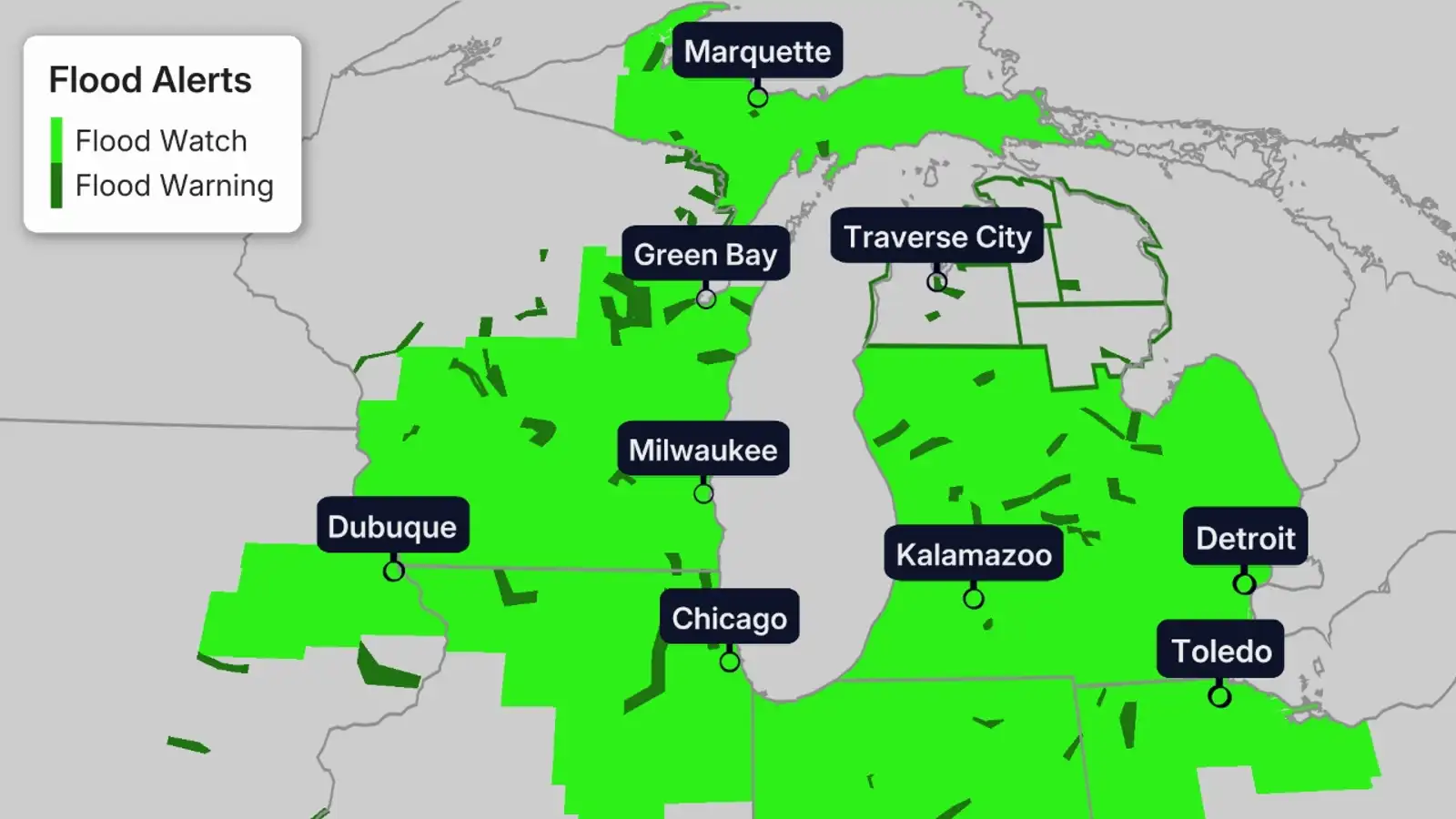
We expect a swath from eastern Kansas to the Midwest and interior Northeast to pick up another 1-inch-plus of rainfall through Saturday. That could include Kansas City, Milwaukee, Chicago, Detroit, Cleveland and Buffalo, among the cities.
Where multiple rounds of thunderstorms or clusters of storms occur, locally heavier rainfall is expected. And that could lead to dangerous flash flooding, particularly in urban areas and those areas whose ground is already saturated.
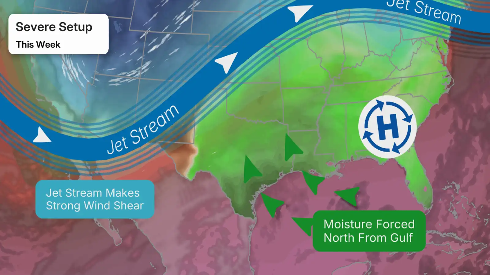
Why The Severe Parade?
What is going on here is actually pretty interesting. We have a high pressure system that is sitting across the eastern U.S. This is forcing Gulf moisture to be pushed northward across the Plains.
We then have southward plunges of the jet stream, or troughs, pivoting out of the West into the Central Plains. Troughs like this generally bring severe weather.
Because of the high pressure system across the East and the aforementioned troughs, severe weather may hit many of the same areas for days.
Recap
Monday and Monday night, there were 18 reports of tornadoes, including sighted tornadoes near Truman, Minnesota, in Taylor County, Wisconsin, and in Miami County, Kansas.
An EF2 was confirmed in Franklin County, Kansas.
Hail up to the size of baseballs or large apples was reported in several areas of southern Minnesota and eastern Kansas.
An overnight squall line of severe thunderstorms knocked out power to almost 90,000 customers in southern Wisconsin. Wind gusts removed a roof of a home in Jefferson, Wisconsin, and damaging siding in Burlington, Wisconsin.
Flash flooding stranded vehicles Monday night in Green Bay and Neenah, Wisconsin.
The combination of heavy rain, warmer air and snowpack has lead to significant flooding in northern Michigan.
Flooding washed out a section of M-119, the “Tunnel of Trees” scenic highway north of Petoskey, Michigan.
Just south of Traverse City, Michigan, the Manistee River near Sherman, Michigan, already obliterated its previous record crest by over 2 feet in records dating to the Great Depression.
Gaylord, Michigan, not only topped its record wet April not even halfway through the month (8.25 inches), but also smashed its record wet spring (14.46 inches) just halfway through, as well.
Both Alpena (2.24 inches) and Houghton Lake (2.97 inches), Michigan, also had their wettest April day on record last Sunday.
Over 410 reports of severe thunderstorms have been received by the National Weather Service since Monday afternoon. That includes 26 reports of tornadoes from Oklahoma to Iowa and Wisconsin.
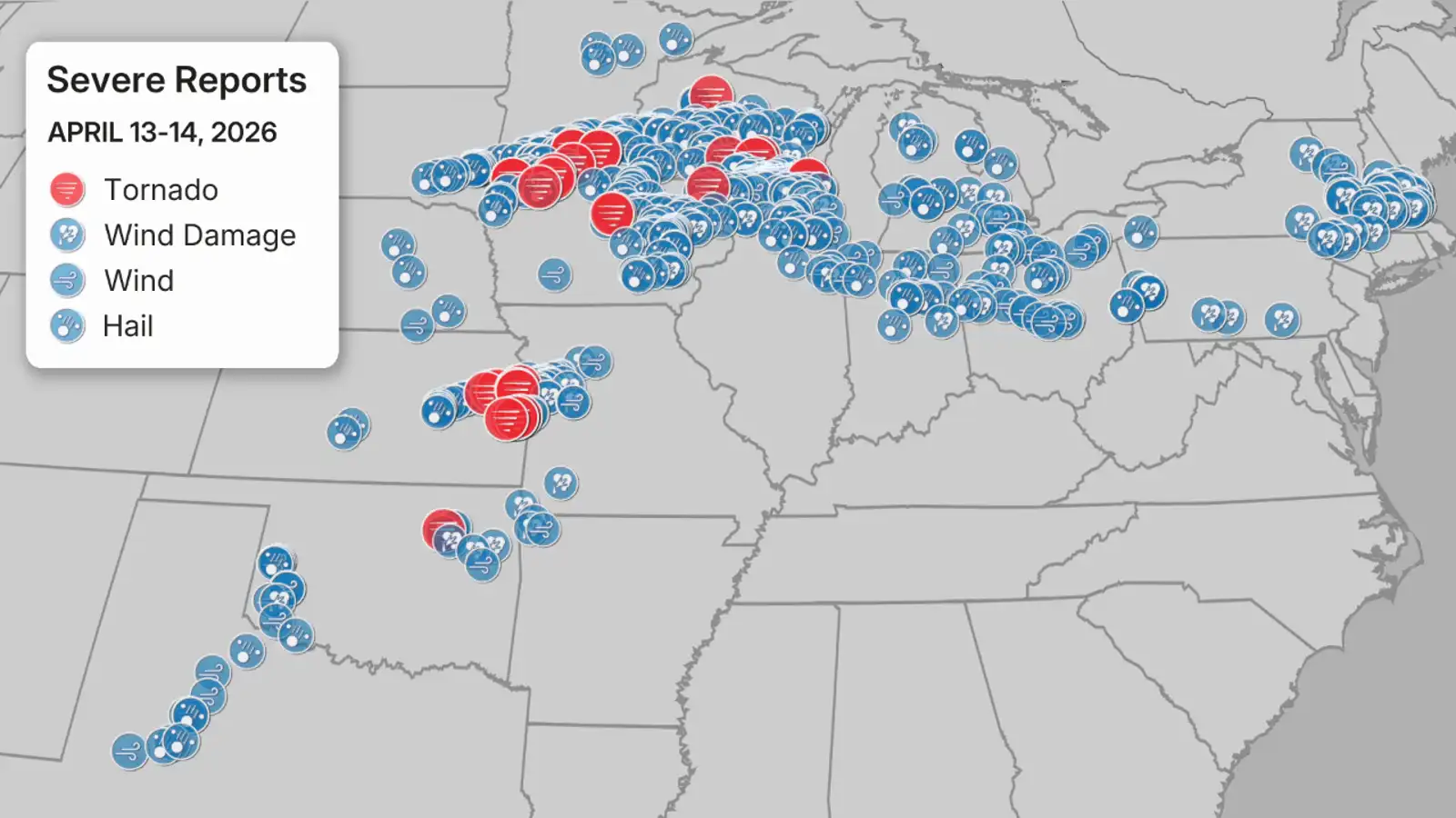
Reports of severe thunderstorms Monday and Tuesday, April 13-14, 2026. Note these are preliminary reports of tornadoes, not necessarily the number of tornadoes that occurred.
(Data: NOAA/NWS/SPC)
Tuesday, a potentially intense tornado destroyed a home near Union City, Wisconsin. The preliminary survey came back that this tornado was an EF3 with estimated peak winds of 140 mph.
Another tornado confirmed by radar took multiple roofs off a commercial facility in the northwest Milwaukee suburb of Sussex and Lisbon. That tornado was rated EF2.
Several tornadoes were documented by storm chasers in Iowa, including one captured in a 360-degree drone video near Wyoming, Iowa. At least one building was damaged near Masonville from a possible tornado.
NWS storm surveys will be conducted to determine the tracks and intensities of tornadoes in the coming days.
Hail from golf ball to softball size pelted Dane County, Wisconsin, including the city of Madison. Siding and roof damage was reported in Black Earth, Wisconsin.
The only other softball-size — 4 inch diameter — hail on record in Dane County prior to Tuesday was on July 2, 1960, according to NOAA’s Storm Events database.
Wind caused significant damage to farm buildings and wooden stakes were impaled into the ground in Delhi, Iowa, on Tuesday evening. Winds gusted as high as 88 mph in Dubuque, Iowa, and 80 mph at Grand Rapids, Michigan.
High winds also lead to roof and structural damage near Chickasaw, Ohio.
In western Oklahoma, winds gusting to 84 mph blew large hail and caused structural damage in Elk City. High winds also damaged a home near Warren, Oklahoma.
Rob Shackelford is a meteorologist and climate scientist at weather.com. He received his undergraduate and master’s degrees from the University of Georgia studying meteorology and experimenting with alternative hurricane forecasting tools.