
The heat event began on Sunday June 22 after the passage of a destructive MCS (mesoscale convective system) across central New York which spun up two brief tornadoes on its leading edge that resulted in three fatalities in the Clark Mills area of Oneida County. In that system’s wake a very humid air mass developed across the region with dewpoints into the low 70s by the afternoon. Cloud cover, however, stuck through the day as a likely result of the moisture increase from the rain with the MCS and rapidly increasing temperatures aloft which strengthened an inversion and prevented much mixing. This allowed a thin deck of low clouds to persist through the day which held temperatures into the 80s, versus the 90s, which would have easily evolved with just an hour or two of sun. But it felt hot with heat indices for an hour or two in the afternoon around 90 degrees.
Full force, “High End” heat for the Northeast then gripped the region on the 23rd and 24th with record temperatures and record high heat indices occurring in many areas.
NOTE: The dewpoint at Albany remained at or above 70 degrees for 37 consecutive hours from noon Sunday June 22 through 1am Tuesday June 23.
Hot weather persisted through Wednesday the 25th, although at a much lower magnitude falling into the more typically hot summer day type category. Still, temperatures moved into the lower 90s in the Hudson valley which made the event an official heat wave in the Capital Region.
The low temperature for the day on the 25th was 74 degrees, which tied the record high minimum of 74 degrees previously set in 1882.
June 23-25, 2025 Heat Wave at Albany
June 23-25, 2025 Heat Wave at Albany
THE MECHANICS OF IT
An almost 600 decameter high pressure ridge aloft (500mb level – Heat Dome) was centered over the central Appalachians at 8am Tuesday June 24, 2025, just past its peak intensity. The position and strength of the ridge during the highest sun angle part of the year favored a period of extreme heat that stretched from southeast Canada through the Northeast on south through the mid Atlantic and west through the Midwest, Ohio, and Tennessee valleys.
Peak heat across the Northeast occurred on Monday June 23rd and Tuesday June 24th with some easing on Wednesday June 25th resulting from the ridge flattening allowing for a weak cold front to drop south.
Significantly cooler and damp weather returned locally and throughout the Northeast on Thursday June 26th.
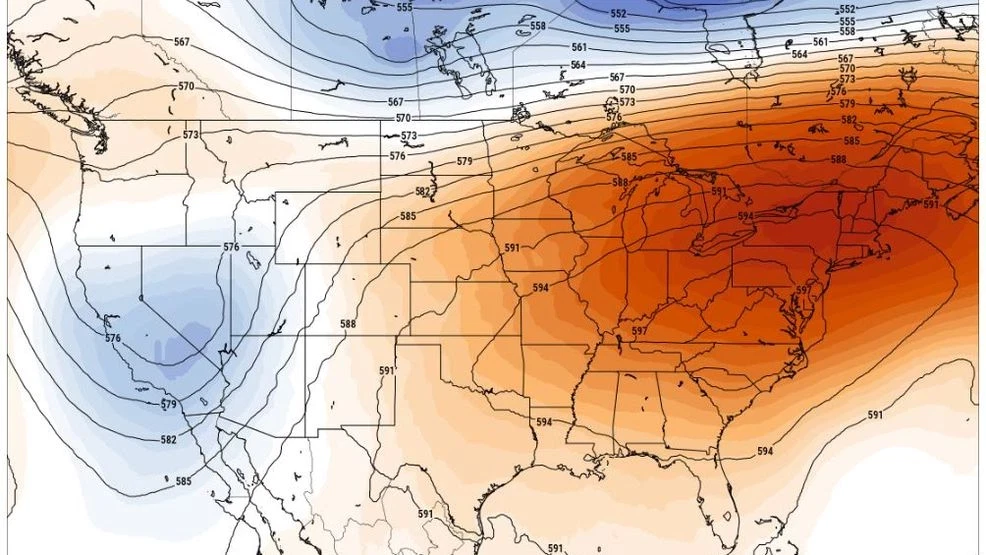
8am Tuesday June 24, 2025 500 mb Height Anomaly Chart
The heat locally during the two day stretch from the 23rd through the 24th was particularly high end both in magnitude as well as duration. Both days featured just about 100% sunshine which allowed for maximum heating due to a well capped atmosphere which prevented clouds and showers and thunderstorms from developing.
Rare extreme heat warnings were issued from 11am Monday the 23rd and continued through 8pm on Tuesday the 24th in the Hudson valley with a heat advisory for the remainder of the region with the exception of the Adirondacks.
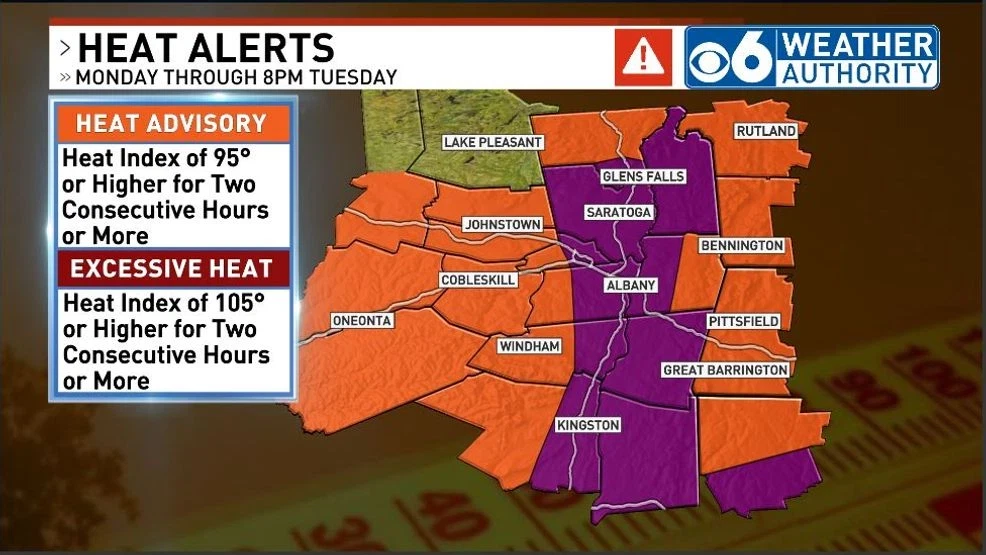
National Weather Service Heat Alerts – June 24, 2025
Monday – June 23
Very warm and humid air had arrived on Sunday the 22nd which set the stage for strong heating to kick in as the sun came up on the 23rd. Temperatures and heat indices surged through the morning and afternoon under light wind conditions.
The temperature at Albany reached 90 degrees at noon and then remained at or above 90 degrees from noon through 8pm, and remained at or above 80 degrees between 9am and 11pm. Heat indices ranged from 102-107 degrees between noon and 7pm (7+ hours,) with the peak heat index at Albany reaching 107 degrees around 2pm. The high temperature for the day was 96 degrees which tied the previous record high for the date of 96 degrees set in 1888.
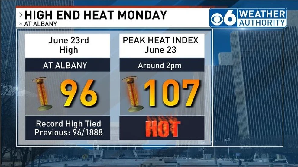
Heat Stats. for Albany June 23, 2025
With high soil moisture from the preceding days of wet weather, dewpoints climbed into the mid and upper 70s through the morning and early afternoon, about as high as they get across the Northeast, then ranged through the low and mid 70s through the afternoon and evening. Atmospheric mixing was shallow with light wind conditions which allowed high dewpoint air to pool in the atmosphere’s boundary layer (near the ground) which supported the all day level of oppressive humidity throughout the region.
The dewpoint at Albany briefly peaked at 77 degrees around noon. The combination of temperatures surging into the 90s and the very high dewpoints pushed heat indices to a range from 100 to 110 degrees on average in the valleys and locally peaking at 117 degrees at the New York State Mesonet site in Whitehall (a record for the site and network to date.)
NOTE: The NYS mesonet site at Whitehall in Washington County is located at Lock C-11 on the Champlain Canal and therefore was able to measure the effects of moisture being evaporated off the canal which locally elevated the dewpoint causing the exceptionally high heat index value at this location.
Observed High Temperatures – Monday June 23, 2025 – New York Mesonet and airport ASOS Observation Sites
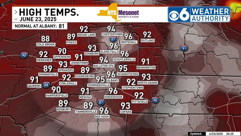
Observed High Temperatures – June 23, 2025
Observed Peak Heat Index – Monday June 23, 2025 – New York Mesonet and airport ASOS Observation Sites
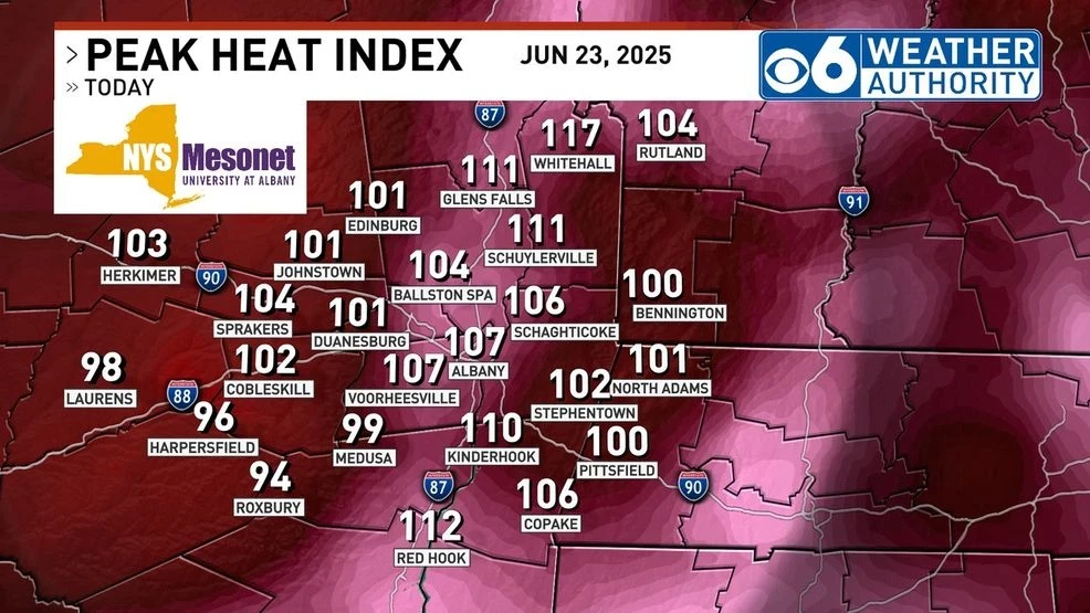
Observed Peak Heat Indices – June 23, 2025
Tuesday – June 24
The character of the heat was a little different on this day in that humidity levels came down a bit, but air temperatures in some areas came in higher than on the 23rd.
The strong high pressure ridge aloft had peaked on the 23rd with this heat dome flattening somewhat on the 24th which allowed more of a westerly flow of air to develop through a more deeply mixed layer in the atmosphere. This did two things, 1) mixed somewhat drier air from aloft down to the surface which allowed dewpoints to drop back into the upper 60s to lower 70s through the day, and 2) caused some downslope compressional warming into especially the mid and upper Hudson valley which, coupled with the lower dewpoint air which is easier to heat, added a couple of extra degrees of warming in those areas. (A southwest wind would have favored downslope warming into the Capital Region, which did not occur.)
Significant downslope warming occurred on the westerly flow into eastern and southern New England as well as south through New York and Philadelphia with many areas seeing high temperatures at or above 100 degrees. Boston topped off at 102 degrees, a record for the month of June, with Providence, RI getting to 100 degrees, also setting the record for the highest temperature observed in June.
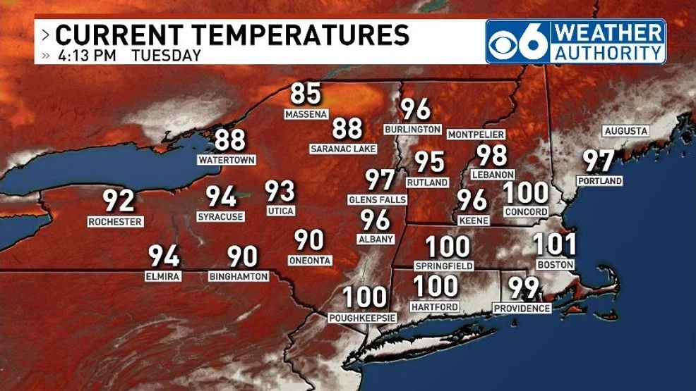
4pm Observed Temperatures July 24, 2025
Winds locally during the afternoon gusted between 20-30 mph which was either pleasant if one was located in a shaded spot under a tree, or more like a blast furnace if one was in the sun or standing in a parking lot.
On average peak heat indices were a few degrees lower on this day versus on Monday throughout the region due to the lower dewpoint air, but high temperatures were either as high or a little higher.
The temperature at Albany climbed to 90 degrees at 11am and remained at or above 90 degrees from 11am through 8pm, and remained at or above 80 degrees from 8am through midnight, both of a little longer duration than on Monday. Heat indices ranged from 101-103 between noon and 5pm (6+ hours, about an hour less than on Monday.) The peak heat index at Albany climbed to 103 degrees around 4pm. The high temperature for the day was 96 degrees which tied the previous record high for the date of 96 degrees set in 1943 and equaled the high reached on the 23rd.
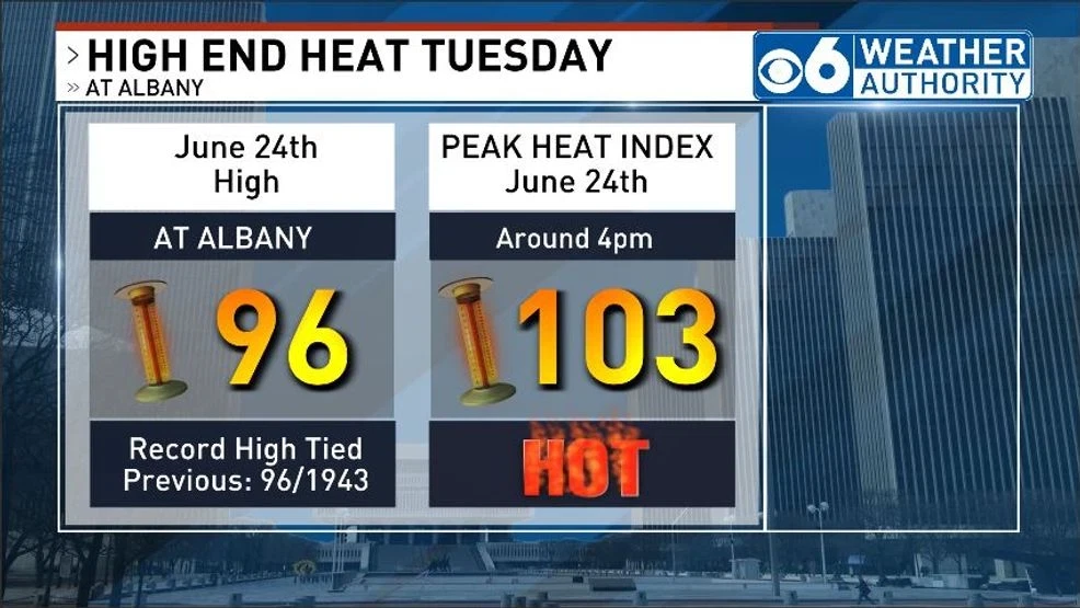
Albany Heat Stats. June 24, 2025
Observed High Temperatures – Tuesday June 24, 2025 – New York Mesonet and airport ASOS Observation Sites
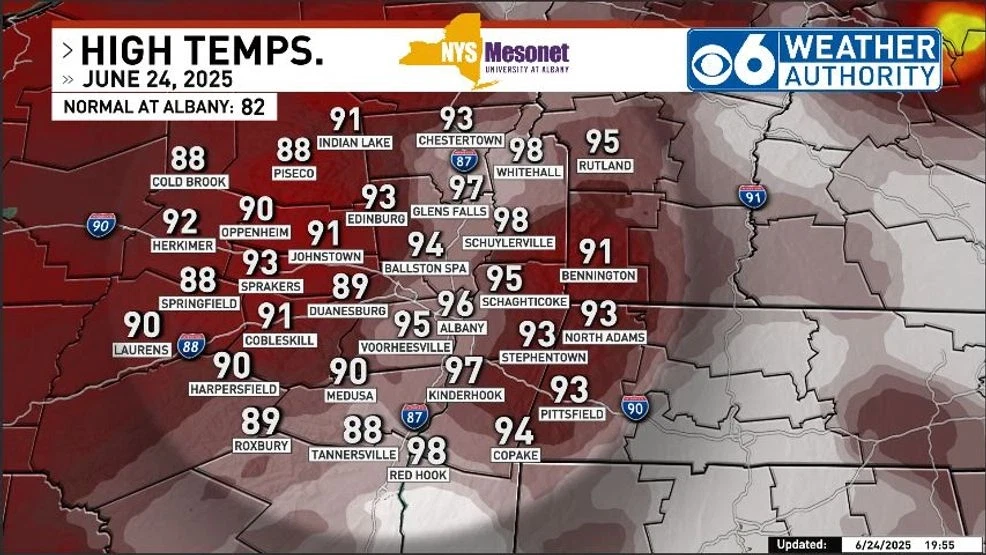
June 24, 2025 Observed High Temperatures
Observed Peak Heat Index – Tuesday June 24, 2025 – New York Mesonet and airport ASOS Observation Sites
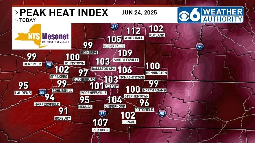
June 24, 2025 Observed Peak Heat Indices
Measuring the magnitude of a heat event consists of both looking at the how high temperatures and heat indices climb as well as the duration of the high heat period. Typically in the local area, we’ll get anywhere from 2-5 consecutive hours with a heat index of 100 degrees or higher in our more extreme events. The duration in this event, however, was longer ranging anywhere from 6-8 hours at Albany on both days.
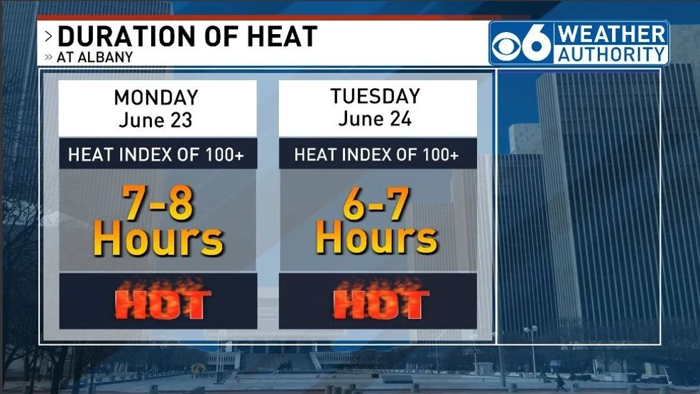
Heat Duration June 24, 2025
Observed High Temperatures – Wednesday June 25, 2025 – New York Mesonet and airport ASOS Observation Sites
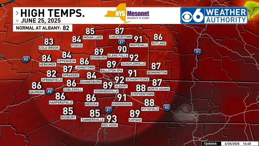
Observed High Temperatures – June 25, 2025