The WXII 12 News weather team is tracking a winter storm that could bring significant snow. >>>Latest weather closings, Weather alerts, Live Radar A Winter Storm Warning has been issued for the entire state of North Carolina, where snowfall may exceed half a foot in the higher elevations. An Excessive Cold Watch is also in effect for all of central North Carolina from late Saturday into Sunday morning.WXII 12 First Warning Weather team snowfall forecast>>>Winter Storm Tracker: Get the latest maps and models here. Winter Storm AlertCurrent thinking Dangerous Travel ConditionsTravel may become difficult quickly on Saturday afternoon across much of the state; snow-covered roads and blowing snow will reduce driving visibility once the storm arrives. Accumulating snowfall is likely by Saturday afternoon for the Piedmont Triad once moisture overcomes dry air. >>>Check out the hour-by-hour winter storm forecast here. Last weekend’s snow and sleet are still lingering, and any additional snow on the ground will delay clearing side roads. Measurable snowfall is likely in the Piedmont Triad most of the day Saturday, with most areas primed to see snowfall totals around 4 inches. Dry, powdery snow is a bit less dense than last weekend’s messy snow event, but temperatures are locked below freezing this time through early Monday morning, so no slick ice, just snow, which will still worsen road conditions. >>>What about county-by-county impacts? Find out what you need to know here. WXII 12 Weather Alert Day SaturdayCold polar air and extreme cold alerts again into the weekendFor more on the bitter cold, find details here about our current cold weather alerts.Winter weather setup for SaturdayA surge of Arctic air has sunk south once again as a deep trough digs into the eastern U.S. When we see a setup like this, a low-pressure systems develop along the leading edge of that cold air, especially near the coast. These systems transport moisture inland, which falls as rain or snow depending on the temperatures of the air mass. Snowfall potentialStorm will take shape with most snow falling on SaturdayMid-level trough will assist with potentially significant snowfall totalsMost of the critical elements needed to bring a weekend storm are forming now. Once the low lifts closer to the shore, we will gain a better understanding of how the storm will be positioned and interact with mid-level energy. Intense winds and low wind chills Saturday and Sunday are likely as a tight pressure gradient develops. Snowfall totals may be higher in spots around the Piedmont and lower in other areas like the Foothills, where dry air could wrap into the storm. The higher totals will most likely be from Central North Carolina in Raleigh toward the Outer Banks, but this is still dependent on the storm track and whether the surface low aligns well with a powerful trough digging into the Carolinas with cold arctic air.Current TemperaturesBombogenesis | Will the snowstorm rapidly intensify near North Carolina’s beaches?There is a possibility that a surface low may merge with a mid-level low as rapid intensification of the storm occurs over the Atlantic near the Outer Banks in North Carolina.What is a bomb cyclone? Dylan Hudler explains in the video below.This bombogenesis could create a bomb cyclone that may help bring blizzard conditions to parts of the Mid-Atlantic coast, including Northeast North Carolina and Southeast Virginia.Piedmont Triad forecastFoothills forecastMountains forecast7-DAY FORECASTMore weather coverage: Weather Alerts | Closing and delays | Latest weather forecast | Post pictures to the uLocal North Carolina Facebook Group | Traffic information | Report closings and delays | SkyCams | Download the WXII12 News mobile appRELATED STORIES
The WXII 12 News weather team is tracking a winter storm that could bring significant snow.
>>>Latest weather closings, Weather alerts, Live Radar
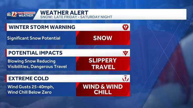
A Winter Storm Warning has been issued for the entire state of North Carolina, where snowfall may exceed half a foot in the higher elevations. An Excessive Cold Watch is also in effect for all of central North Carolina from late Saturday into Sunday morning.
WXII 12 First Warning Weather team snowfall forecast
This content is imported from Facebook.
You may be able to find the same content in another format, or you may be able to find more information, at their web site.
>>>Winter Storm Tracker: Get the latest maps and models here.
This content is imported from Facebook.
You may be able to find the same content in another format, or you may be able to find more information, at their web site.
Winter Storm Alert
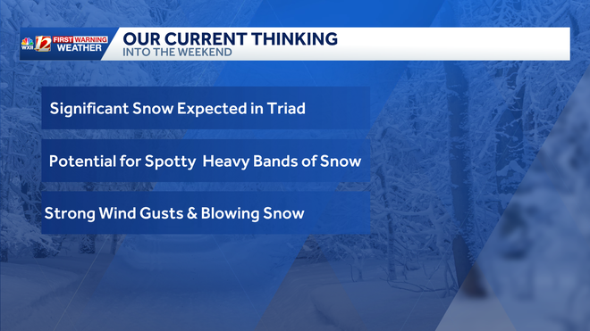
Current thinking
Dangerous Travel Conditions
Travel may become difficult quickly on Saturday afternoon across much of the state; snow-covered roads and blowing snow will reduce driving visibility once the storm arrives. Accumulating snowfall is likely by Saturday afternoon for the Piedmont Triad once moisture overcomes dry air.
>>>Check out the hour-by-hour winter storm forecast here.
Last weekend’s snow and sleet are still lingering, and any additional snow on the ground will delay clearing side roads. Measurable snowfall is likely in the Piedmont Triad most of the day Saturday, with most areas primed to see snowfall totals around 4 inches. Dry, powdery snow is a bit less dense than last weekend’s messy snow event, but temperatures are locked below freezing this time through early Monday morning, so no slick ice, just snow, which will still worsen road conditions.
>>>What about county-by-county impacts? Find out what you need to know here.
WXII 12 Weather Alert Day Saturday
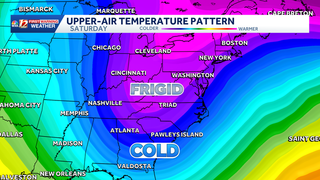
Cold polar air and extreme cold alerts again into the weekend
For more on the bitter cold, find details here about our current cold weather alerts.
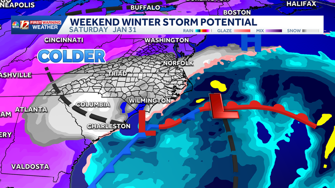
Winter weather setup for Saturday
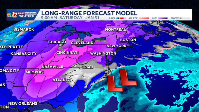
A surge of Arctic air has sunk south once again as a deep trough digs into the eastern U.S. When we see a setup like this, a low-pressure systems develop along the leading edge of that cold air, especially near the coast. These systems transport moisture inland, which falls as rain or snow depending on the temperatures of the air mass.
Snowfall potential
Storm will take shape with most snow falling on Saturday
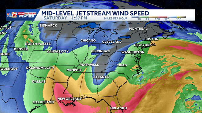
Mid-level trough will assist with potentially significant snowfall totals
Most of the critical elements needed to bring a weekend storm are forming now. Once the low lifts closer to the shore, we will gain a better understanding of how the storm will be positioned and interact with mid-level energy. Intense winds and low wind chills Saturday and Sunday are likely as a tight pressure gradient develops. Snowfall totals may be higher in spots around the Piedmont and lower in other areas like the Foothills, where dry air could wrap into the storm. The higher totals will most likely be from Central North Carolina in Raleigh toward the Outer Banks, but this is still dependent on the storm track and whether the surface low aligns well with a powerful trough digging into the Carolinas with cold arctic air.
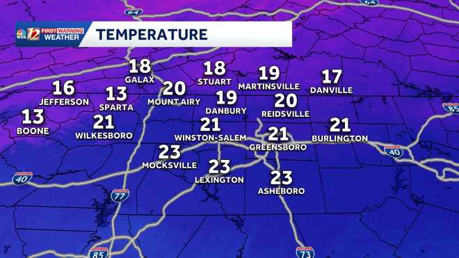
Current Temperatures
Bombogenesis | Will the snowstorm rapidly intensify near North Carolina’s beaches?
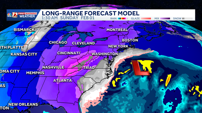
There is a possibility that a surface low may merge with a mid-level low as rapid intensification of the storm occurs over the Atlantic near the Outer Banks in North Carolina.
What is a bomb cyclone? Dylan Hudler explains in the video below.
This bombogenesis could create a bomb cyclone that may help bring blizzard conditions to parts of the Mid-Atlantic coast, including Northeast North Carolina and Southeast Virginia.
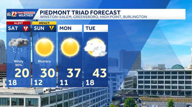
Piedmont Triad forecast
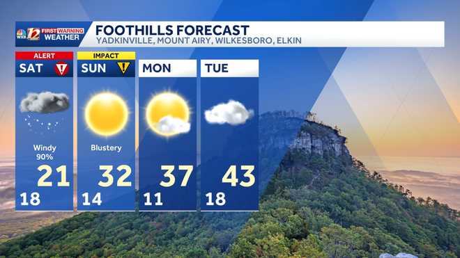
Foothills forecast
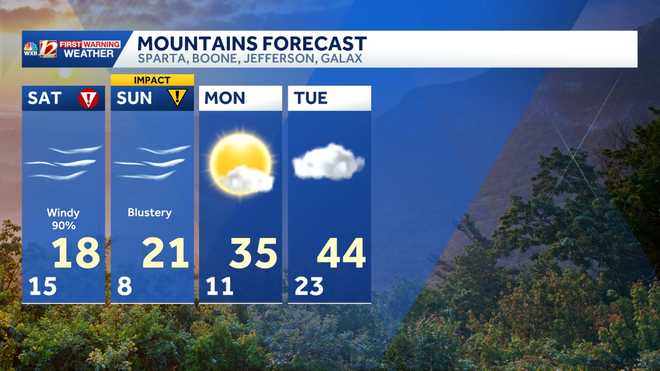
Mountains forecast
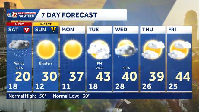
7-DAY FORECAST
More weather coverage: Weather Alerts | Closing and delays | Latest weather forecast | Post pictures to the uLocal North Carolina Facebook Group | Traffic information | Report closings and delays | SkyCams | Download the WXII12 News mobile app
RELATED STORIES

