
MINNEAPOLIS (FOX 9) – Severe storms are moving across Minnesota overnight, with severe thunderstorm warnings already issued in parts of western Minnesota. Damaging winds, hail, heavy rain and an isolated tornado remain possible as storms track east toward the Twin Cities.
We had a hot and steamy Tuesday, which is leading up to the possibility of strong to severe thunderstorms for parts of Minnesota overnight into Wednesday morning. Find the latest updates below.
Stay sky aware and stay with FOX 9 as Chief Meteorologist Ian Leonard will keep us updated overnight as it merits.
3:20 a.m. – Severe thunderstorm warning for some metro counties
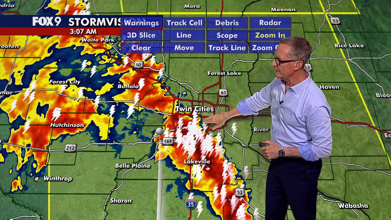
Thunderstorms push into Twin Cities metro early Wednesday
FOX 9 Meteorologist Ian Leonard is tracking severe storms rolling into Minnesota overnight. As of 3 a.m., a line of thunderstorms has pushed into the Twin Cities metro, with reports of 40+ mph wind gusts, thunder, and lightning.
A severe thunderstorm warning has been issued for parts of the northeast metro, including Anoka, Chisago, Ramsey and Washington counties. The warning extends into parts of Wisconsin, including Polk and St. Croix counties.
Small hail and wind gusts up to 60 mph are possible. The warning is in place until 4 a.m. on Wednesday.
3 a.m. – Special weather statement for central Minnesota
The National Weather Service has issued a special weather statement for areas of Ramsey, Elk River and Otsego until 4 a.m. on Wednesday.
Wind gusts up to 50 mph and pea sized hail are possible.
2:50 a.m. – Severe thunderstorm warnings in central Minnesota
A severe thunderstorm warning is in effect until 3:45 a.m. for Clearwater, Pennington, Polk and Red Lake counties. Otter Tail County is under a thunderstorm warning until 3:15 a.m.
The Twin Cities metro is starting to see lightning, thunder and wind gusts early at around 40 mph Wednesday morning.
2:40 a.m. — Special weather statement for metro area
The National Weather Service has issued a special weather statement for areas of the Twin Cities metro, including Minneapolis, St. Paul and Bloomington until 3:30 a.m. on Wednesday.
Wind up to 40 mph and pea size hail are possible.
Twin Cities metro under Severe Thunderstorm Watch until 7 a.m.
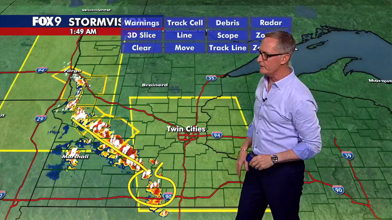
As severe storms start to roll into southwestern Minnesota and head east to northeast, the National Weather Service issued a new Severe Thunderstorm Watch until 7 a.m.
It includes the entire Twin Cities Metro area, while extending northwest to St. Cloud and southeast to Mankato, Northfield, Austin and Rochester. It also extends into western Wisconsin.
Severe Thunderstorm Warnings in Swift, Chippewa Counties
The National Weather Service issued a Severe Thunderstorm Warning for Swift and Chippewa Counties until 2 a.m.
Cities impacted include Benson, Appleton and Milan, Minn. The storm is expected to contain wind gusts up to 80 mph.
Severe Thunderstorm Warnings in Lac qui Parle, Yellow Medicine Counties
The National Weather Service issued a Severe Thunderstorm Warning for Lac qui Parle and Yellow Medicine Counties until 1:30 a.m. Communities impacted include Canby, Madison and Dawson, Minn.
Tornado Watch until 3 a.m. Wednesday for southwestern MN
Parts of far northwestern Minnesota are under a Tornado Watch until 3 a.m. Wednesday. The areas impacted include Cottonwood, Jackson, Lincoln, Lyon, Murray, Nobles, Pipestone and Rock Counties.
Severe Thunderstorm Watch until 4 a.m.
What we know:
The National Weather Service issued a Severe Thunderstorm Watch for parts of Minnesota, North Dakota and South Dakota until 4 a.m. Wednesday. The areas potentially impacted include far western and northwestern Minnesota.
The watch goes as far south as near Marshall and extends to Montevideo, Morris, Alexandria, Wadena, Detroit Lakes, Fargo-Moorhead and as far north as Roseau.
The watch does not currently include any counties in or near the Twin Cities metro.
All forms of severe weather possible overnight, including damaging straight line winds, brief tornadoes and large hail 2″-3: and localized heavy rain/flooding.
Storm chances late Tuesday night
The backstory:
Thunderstorms are expected to develop in the Dakotas this evening and move into western Minnesota around midnight before spreading east overnight. The greatest storm chances run from 10 p.m. to 4 a.m. in western and central Minnesota and from 1 a.m. to 5 a.m. in the Twin Cities metro.
Western and central Minnesota are under a level 2 slight risk and level 3 enhanced risk of severe weather, while the Twin Cities metro remains under a level 1 and level 2 risk.
The primary threat is damaging wind gusts over 60 mph. Large hail ranging from 0.50 to 1.50 inches in diameter is also possible, along with localized heavy downpours. An extremely isolated quick spin-up tornado cannot be ruled out.
What we don’t know:
Storms are expected to weaken as they move east into a more stable environment, but they may still produce strong winds and heavy rain overnight. How these storms evolve could also have a significant impact on the potential for another round of storms Wednesday afternoon and evening.
Extended Minnesota weather forecast
What’s next:
Wednesday stays warm and humid, with patchy sunshine and additional storm chances developing through the afternoon and evening.
The Twin Cities metro, much of Wisconsin, and parts of Iowa and Illinois are under a level 3 enhanced risk for severe weather. Damaging winds, large hail, and isolated tornadoes could be possible.