A light rain/snow mix will move through Wisconsin Wednesday night and bring with it a little bit of ice. Timing and how much ice could accumulate here COPYRIGHT 2026 BY CHANNEL 3000. ALL RIGHTS RESERVED. THIS MATERIAL MAY NOT BE PUBLISHED, BROADCAST, REWRITTEN OR REDISTRIBUTED.
Download the First Warn Weather app here
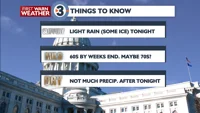
WHAT WE’RE TRACKING:
Light rain/freezing rain mix tonight
Milder weather by weeks end (70s?)
Not much precipitation after tonight
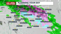
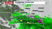
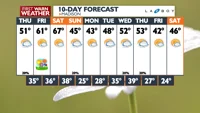
PLANNINGTHE NEXT24HOURS: Light rain is expected overnight, with some freezing rain mixing in at times. Other than lingering rain early Thursday morning, most of the day Thursday will be dry with highs warming up to around 50° under partly to mostly cloudy skies.
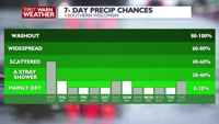
EXTENDEDFORECAST: Conditions dry up and warm up throughout the week with highs in the 60s Friday and then upper 60s Saturday. We cool back down to near normal temperatures with a chance of rain returning Sunday. It will also be breezy for this upcoming weekend.
COPYRIGHT 2026 BY CHANNEL 3000. ALL RIGHTS RESERVED. THIS MATERIAL MAY NOT BE PUBLISHED, BROADCAST, REWRITTEN OR REDISTRIBUTED.
Right Now
37°
Partly Cloudy
Humidity: 64%
Feels Like: 34°
Heat Index: 37°
Wind: 5 mph
Wind Chill: 34°
UV Index: 0 Low
Sunrise:07:04:36 AM
Sunset:07:08:03 PM
Dew Point: 27°
Visibility: 10 mi
Today
Mostly cloudy with scattered light rain and freezing rain showers. Some snow may mix in.
Wind: S 5-10 MPH
Tonight
Mostly cloudy with scattered light rain and freezing rain showers. Some snow may mix in.
Wind: S 5-10 MPH
Tomorrow
Mostly cloudy and milder with a slight chance of rain early.
Wind: E 5-10 MPH
Wed Wednesday
40°/31°
Late night rain mixed with ice. Lows overnight in the upper 20s.
Wednesday Night
Mostly cloudy with scattered light rain and freezing rain showers. Some snow may mix in.
Wind: S 5-10 MPH
Thu Thursday
51°/35°
Partly cloudy. Highs in the mid 50s and lows in the upper 30s.
Thursday Night
Mostly cloudy and a little milder.
Wind: S 5-10 MPH
Fri Friday
61°/36°
Morning clouds followed by afternoon sun. Highs in the upper 60s and lows in the upper 30s.
Friday Night
Mostly cloudy.
Sat Saturday
67°/38°
Partly cloudy. Highs in the low 70s and lows in the low 40s.
Saturday Night
Partly cloudy with a slight chance of showers.
Sun Sunday
45°/25°
Mostly cloudy. Highs in the upper 40s and lows in the mid 20s.
Sunday Night
Partly cloudy and cool.
Mon Monday
43°/28°
Plenty of sun. Highs in the mid 40s and lows in the low 30s.
Monday Night
Partly cloudy and cool.
Tue Tuesday
48°/35°
Cloudy. Highs in the low 50s and lows in the low 30s.
Tuesday Night
Mostly cloudy with a slight chance of rain showers.
Wed Wednesday
52°/39°
Cloudy. Highs in the mid 50s and lows in the mid 40s.
Wednesday Night
Mostly cloudy with a slight chance of rain showers.
Thu Thursday
53°/27°
Times of sun and clouds. Highs in the low 60s and lows in the low 20s.
Thursday Night
Partly cloudy, breezy, and cool with a slight chance of snow.
Fri Friday
42°/24°
Mix of sun and clouds. Highs in the upper 30s and lows in the low 20s.