
I’ll start with the Globe Weather HQ’s official winter outlook, and then take a look at the science pieces behind the forecast.
Coastal New England (I-95 and east)
We’re looking at a winter that’s most likely a touch warmer than average overall, but one that’s bookended by a colder start and a warm-up on the backside. Precipitation should deliver more rain than normal, and likely more snowfall than we’ve seen in recent years, although still below the longtime average.
Interior New England (west, north of I-95)
Interior sections of our region will most likely steer colder than average with a bit more snow than normal. There could be a few higher elevations that see a decent snowfall this season, which would be great for skiing and other snow sports.
Three main puzzle pieces have revealed a very high chance of what we can expect this winter. Those deciding factors are: A weak, short-lived La Niña, a negative QBO phase, and a negative PDO phase. I’ll break down what all of these mean.
Remember, forecasting just one storm during the winter is extremely challenging, let alone an entire season, but it’s always nice to have more clues to solve the riddle.
A negative, easterly Quasi-Biennial Oscillation means colder shots of air
What would winter be without a mention of the polar vortex, a band of upper-level winds holding extremely cold air at the poles. When the vortex weakens, pockets of Arctic air can slip south into the United States. Meteorologists call these “cold snaps” or spells, or simply refer to the polar vortex when this type of cold air is on the way.
At the equator, there is a similar band of upper-level winds circumventing the globe, called the Quasi-Biennial Oscillation. Naturally, these stratospheric winds can change speed and direction based largely on what tropical activity is happening closer to the surface.
Heading into this winter, we will remain in an easterly, negative QBO. What does this mean? This wind direction will actually push against and slow the momentum of the westerly flow that is the polar vortex, making it weaker and sending more frequent shots of frigid, cold air into the U.S. and possibly New England.

When a steadfast negative QBO is in place, the winter across the eastern half of the country runs about a degree or two cooler than normal. That’s important because we’re currently experiencing the strongest negative QBO since 2014, when that winter ran a few degrees cooler than average across all six New England states.
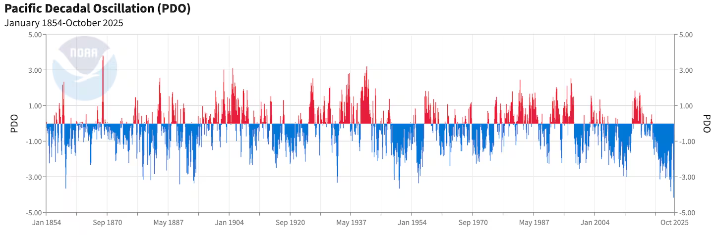
The Pacific Decadal Oscillation – and less snowfall?
This climate pattern refers to the sea surface temperature of the Northern Pacific Ocean. This will impact the placement of the jet stream and, ultimately, the type of weather we see in New England. This is another naturally occurring cycle that fluctuates every 20 to 30 years.
We are currently in a negative phase, which we have been in since 2020, meaning the waters in the Northern Pacific are warmer than normal. The resulting trend in our region from a negative PDO is mild temperatures, resulting in lower snowfall totals and less intense storms.
With the QBO and PDO working against each other this winter, there will likely be a vastly different winter between Boston and Portland versus Springfield and Burlington.
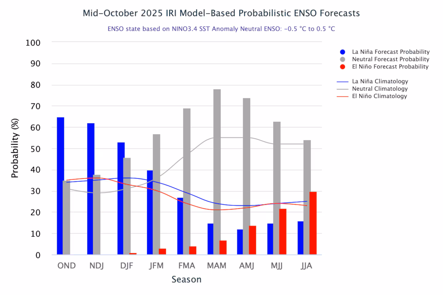
What a brief, but weak La Niña means for our winter
We are seeing this latest La Niña turning weaker and more short-lived with each model run, so I am putting less and less stock into this climate pattern’s impacts this winter. A La Niña during winter typically places New England right in the bull’s eye for storm tracks.
But New England also sees an uptick in temperature during La Niña winters, with a little less snow along the coast, but a bump up in snow totals across the interior. In general, La Niña makes the weather pattern more variable with a mixed bag of elements as a result.
However, I don’t see this La Niña being much of a player for New England weather this year, as it may be over before we begin to see the impacts.
I will say, based on what I’ve seen this summer and fall, that New England will probably continue to remain in the path of the major storm track this winter.
The winter equation answered
So, with a weak, likely uneventful La Niña plus a negative QBO and a negative PDO, what type of winter will we see?
• More snow west and north of I-95, with below-average snow along the coast. Snow totals will likely be just a nudge above normal across Western and Northern New England.
• We’ll likely see more storms pass through, but the intensity will be rather mild.
• Temperatures will fluctuate region-wide, as they always do, but we may be in for a colder start followed by a warmer finish.
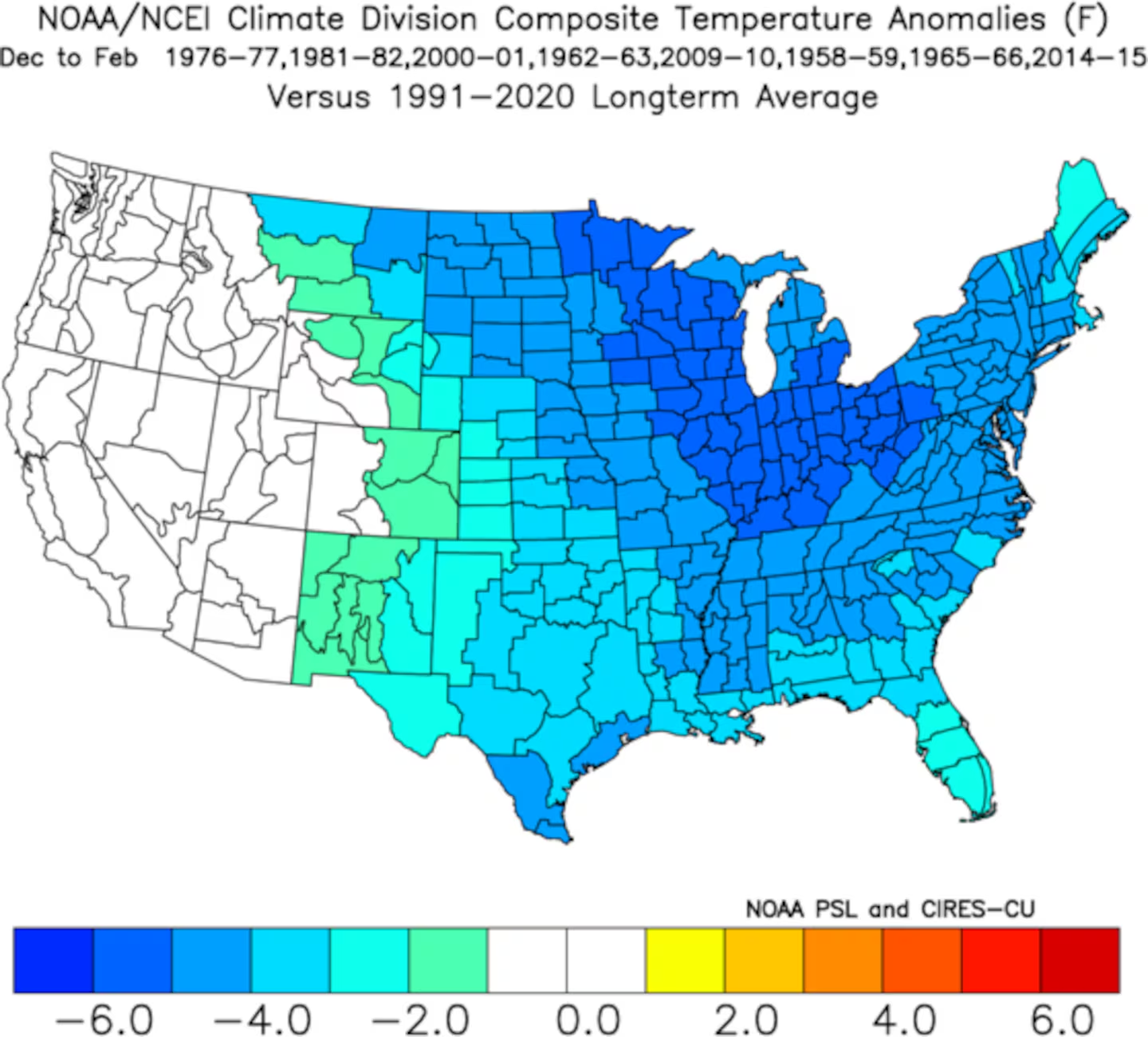
New England has seen two winters with a similar ‘trifecta’ setup in the past decade, and both produced a snowier winter away from the coast.
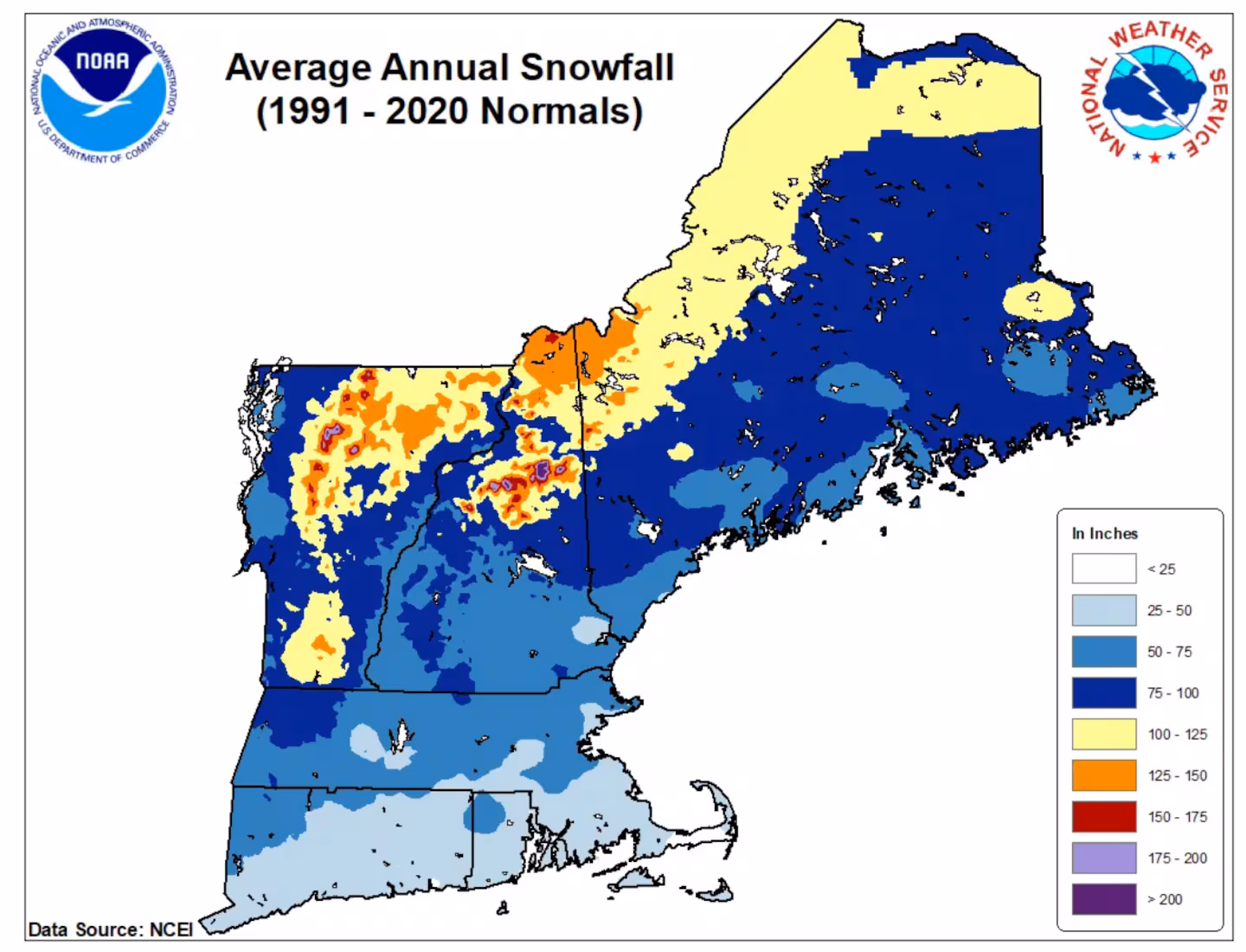
Take a look at the average seasonal snowfall across New England.
When was Boston’s last snowy winter?
Boston hasn’t seen an eyebrow-raising winter since the record-setting 2014-15 season, when nearly 100 inches of snow fell. The strange part? We were in the depths of a prolonged El Niño event — the exact opposite of what is likely to come this season.
Last winter, Boston saw over 2 feet of snow, 28.1 inches to be exact. In 2023-24, Boston saw a steep drop from the average snowfall, picking up only 9.8 inches, the fourth-lowest snow total on record, dating back to 1890. And the previous year, winter 2022-23, also a mild season, generated only 12.4 inches of snow.
However the weather unfolds this winter, it will be nice to see some healthy snowfall totals across the region. A New England winter wonderland will not only help the ski and snowsport industry, but will also rejuvenate the water table, local ecology, and make the holidays just that much more festive.
Meteorological winter begins Dec. 1 and astronomical winter on Dec. 21. Stay weather aware and prepared by signing up here for our daily Globe Weather Forecast that will arrive straight into your inbox bright and early each weekday morning.
Ken Mahan can be reached at ken.mahan@globe.com. Follow him on Instagram @kenmahantheweatherman.