
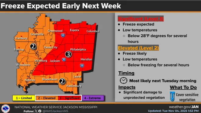
A polar air mass is expected to dip into the Deep South and much of Mississippi is predicted to see its first hard freeze of the season and ahead of that, a severe weather threat has been issued for part of the state and tornadoes cannot be ruled out.
“The main deal is we’re looking at a pretty strong system developing in Central Canada and that is going to steer a polar air mass,” said Nicholas Fenner, senior meteorologist with the National Weather Service in Jackson. “Cold Canadian air is going to come down to the Rockies and settle down along the Gulf Coast Sunday night into Monday and our coldest will be Monday night into Tuesday.
“Pretty much most of the state has a chance of being 32 degrees or cooler. In Jackson, we have a forecast of 30 degrees.”
Will there be a record cold? Probably not. Fenner said while the expected low in Jackson on Tuesday is around 30 degrees, the record low for Jackson on Nov. 11 is 25 degrees, but the cold will be significant. According to NWS Jackson, some parts of the state, particularly in the northeast portion down to near the U.S. 84 corridor, could see prolonged lows near 28 degrees and damage to unprotected vegetation is expected.
Severe storms possible in MS this week
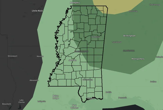
In addition to frosty conditions early next week, the National Weather Service has issued a severe weather threat for North and Northeast Mississippi later this week that may bring damaging wind gusts, hail and possible tornadoes.
From Southaven down to roughly the Interstate 20 corridor east of Jackson and east, a Level 1 risk warning has been issued for Friday afternoon into Friday evening. In addition to rain and thunderstorms, the system could produce damaging winds up to 60 miles per hour along with hail up to quarter-size. According to the National Weather Service, tornadoes cannot be ruled out.
In the extreme northeast corner of the state, there is a Level 2 risk, which means it’s at greater risk of severe storms, hail, damaging winds and possible tornado development.
How cold will it get in MS near me?
According to the National Weather Service forecast on Wednesday morning, here are some of the expected low temperatures around the state on Tues., Nov. 11.
- Southaven: 30 degrees
- Corinth: 27 degrees
- Oxford: 28 degrees
- Columbus: 27 degrees
- Starkville: 27 degrees
- Greenwood: 29 degrees
- Jackson: 31 degrees
- Vicksburg: 32 degrees
- Meridian: 28 degrees
- Brookhaven: 29 degrees
- Natchez: 31 degrees
- Hattiesburg: 31 degrees
- Wiggins: 34 degrees
- Biloxi: 37 degrees
National Weather Service Forecast in, near Jackson
- Wednesday: Sunny, with a high near 77. Calm wind becoming southwest around 5 mph.
- Wednesday Night: Patchy fog after 9 p.m. Otherwise, mostly clear, with a low around 49. Calm wind.
- Thursday: Patchy fog before 8 a.m. Otherwise, sunny, with a high near 78. Calm wind becoming south-southeast around 5 mph in the afternoon.
- Thursday Night: Partly cloudy, with a low around 59. South wind around 5 mph.
- Friday: A chance of showers, with thunderstorms also possible after noon. Mostly sunny, with a high near 80. South-southwest wind 5 to 10 mph. Chance of precipitation is 40%.
- Friday Night: A chance of showers and thunderstorms. Partly cloudy, with a low around 61. South wind around 5 mph becoming calm in the evening. Chance of precipitation is 30%.
- Saturday: Sunny, with a high near 82. Calm wind becoming west-southwest around 5 mph in the morning.
- Saturday Night: A 20% chance of showers after midnight. Mostly clear, with a low around 54. West wind around 5 mph becoming north northwest after midnight.
- Sunday: Sunny, with a high near 65. North-northwest wind 10 to 15 mph, with gusts as high as 20 mph.
- Sunday Night: Clear, with a low around 36.
- Monday: Sunny, with a high near 52.
- Monday Night: Clear, with a low around 31.
- Veterans Day: Sunny, with a high near 60.
National Weather Service Forecast in, near Hattiesburg
- Wednesday: Patchy fog before 9 a.m. Otherwise, sunny, with a high near 79. Calm wind.
- Wednesday Night: Patchy fog after 9 p.m. Otherwise, mostly clear, with a low around 50. Calm wind.
- Thursday: Patchy fog before 8am. Otherwise, sunny, with a high near 79. Calm wind becoming southeast around 5 mph.
- Thursday Night: Partly cloudy, with a low around 59. South-southeast wind around 5 mph becoming calm.
- Friday: A slight chance of showers, then a chance of showers and thunderstorms after 9 a.m. Partly sunny, with a high near 81. Light south-southeast wind becoming south 5 to 10 mph in the morning. Chance of precipitation is 40%.
- Friday Night: A slight chance of showers and thunderstorms, then a chance of showers after 9 p.m. Partly cloudy, with a low around 63. South wind around 5 mph becoming calm in the evening. Chance of precipitation is 30%.
- Saturday: Mostly sunny, with a high near 83. Calm wind becoming west-southwest around 5 mph in the morning.
- Saturday Night: A 20% chance of showers after midnight. Partly cloudy, with a low around 60. Calm wind becoming west around 5 mph after midnight.
- Sunday: Sunny, with a high near 71. North-northwest wind 5 to 15 mph, with gusts as high as 20 mph.
- Sunday Night: Clear, with a low around 40.
- Monday: Sunny, with a high near 56.
- Monday Night: Clear, with a low around 31.
- Veterans Day: Sunny, with a high near 61.
Do you have a story idea? Contact Brian Broom at 601-961-7225 or bbroom@gannett.com.